Description
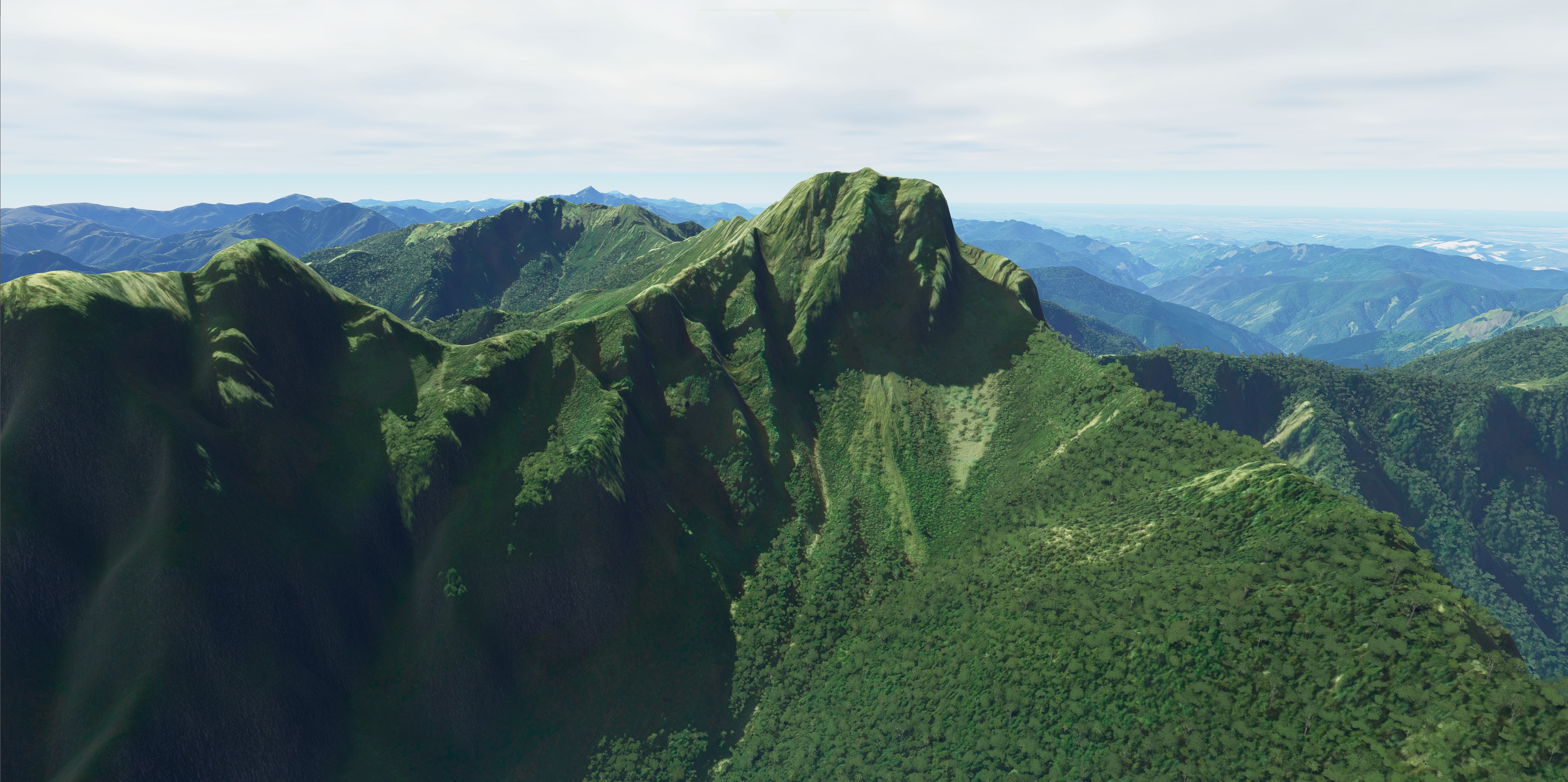
Taiwan is a mountainous country locates at Southeast Asia. The major island covers around 36000 square km area. The highest mountain is Yu Shan aka Mount Jade with 3952m elevation. There are 100+ peaks higher than 3000m in Taiwan. This project provides 20m DEM source for whole Taiwan Island, including remote islands like Guishan Island, Green Island, Lanyu Island, and Liuqiu Island. If you like mountainous terrain and natural environment, this is a great place to visit.
Other islands DEM belongs to Taiwan's territory like Kinmen or PengHu will be provided from separated packages.
Note, some airport's terrain may be distorted due to nature of the data source. Main hubs like RCTP, RCSS, RCKH, or RCFN have been evaluated without any significant spikes. Future updates are planned to terraform other airports in Taiwan. Please also be aware that your hardware performance maybe impacted due to increased terrain detail.
Installation: drag and drop the 'fsformosa-Taiwan-DEM' in your Community folder. Remove 'kcai-Taiwan-DEM' and "kcai-taiwan-dem-apfix" folder in your Community folder if you have previous version installed.
Credits: Thanks for Morko's great DEM tools for one more step ahead.
Commentaires(25)
Connectez-vous pour participer à la discussion
Se connecterabout 2 years ago
over 3 years ago
Looks beautiful but my FPS went down severely once I began flying over the island. I hope to see an update one day.
EDIT - I'm not too sure if it is giving bad performance now. I reload the sim at RCKH and now it works fine. changed from 3 to 4 stars.
about 4 years ago
The flight over the area is lag when using this addon. please fix it. Tkx
about 4 years ago
as some people before me wrote, after world update 9, the DEMs stopped working fine, same with formosa DEM, Mikea.at DEM or Troglodytus DEM... only the CGL meshs by Orbx work fine
over 4 years ago
Nice work. However, I found that this mod causes performance drop and frame stuttering when flying above 15000 feet. My config:
Intel i-964GB ramRTX 2060 super (6GB ram)MSFS SU8Graphics quality: High-Endover 4 years ago
Got same problem here, so far no good solution for this, an MSFS internal issue.
over 4 years ago
Yes, it was OK before SU8
about 4 years ago
yeah, something with SU8 broke it, damn it
5900X
64GB RAM
3080 TI
over 4 years ago
Thank you so much for your great work.
I really really enjoy "Every Bit" of Taiwan.
about 5 years ago
masterpiece
Eluanbi, Cingjing Farm, Yushan, Sun Moon Lake, they have all gained noticeable improvement! !
about 5 years ago
Taiwan 20m DEM
Explore the mountainous terrain of Taiwan with this Microsoft Flight Simulator add-on providing a 20m DEM source for the entire island, including remote islands like Guishan, Green, Lanyu, and Liuqiu. With over 100 peaks exceeding 3000m in elevation, Taiwan offers a diverse and natural environment for virtual pilots to discover. Note that some airport terrains may be affected, but main hubs have been evaluated for smooth operation. Install the package in your Community folder for an enhanced flying experience over Taiwans stunning landscapes.

Avis des utilisateurs
9 avis
Location
More Information
Historique des versions
Remove support for all other airports (They will be supported separately). Now only one folder is required to install.
Similaires

Swiss mountains tree fix (trees on mountains removed)
A comprehensive mod fixing tree placement on Swiss mountains, particularly removing inaccurately placed trees on mountain peaks. The update includes a shift to more realistic conifer trees in the Alps and an expansion to border areas of France, Italy, and Austria. From Alpstein Säntis to Stockhorn, numerous locations across Switzerland have been meticulously corrected for a more authentic flight experience.
par THEOLI4D

Shorter Trees / Tree Height Modification VERSION 4.0 for MFS2020 (shorter, realistic trees)
Experience realistic and shorter trees in Microsoft Flight Simulator with the Shorter Trees / Tree Height Modification VERSION 4.0 add-on. Compatible with the latest version of MSFS, this mod provides adjusted tree heights for a more authentic flying experience. Update includes enhanced tree coloration blending seamlessly with photogrammetry trees. Installation is simple - just copy the folder into your community folder and enjoy a new perspective from the skies.
par ARIF STUDIOS - Adnan Arif

AUSTRIA 10m DEM - High Resolution Terrain Elevation Data from LIDAR Imaging
Explore the stunning terrain of Austria with this mod featuring high-resolution LIDAR data, offering a mesh resolution of 10m for a more realistic flight experience. Flatten lakes, rivers, and eliminate any terrain artifacts as you soar over the Austrian landscape. Divided into regions for convenience and performance optimization, this mod enhances the mountain shapes to mirror reality and provides a smoother flying experience. Experience Austria like never before with enhanced elevation data and realistic terrains.
par Troglodytus

SWITZERLAND 20m DEM - High Resolution Terrain Elevation Data from LIDAR Imaging
Explore the beauty of Switzerland with this mod offering high resolution terrain elevation data using LIDAR imaging. The mesh resolution is 20m, providing exceptional detail with a height resolution of 0.1m. Update includes extreme LIDAR meshes for specific regions. Please note potential performance impacts and report any bugs for further improvements. Fly VFR over Switzerland with enhanced realism and accuracy.
par Troglodytus
6 months ago