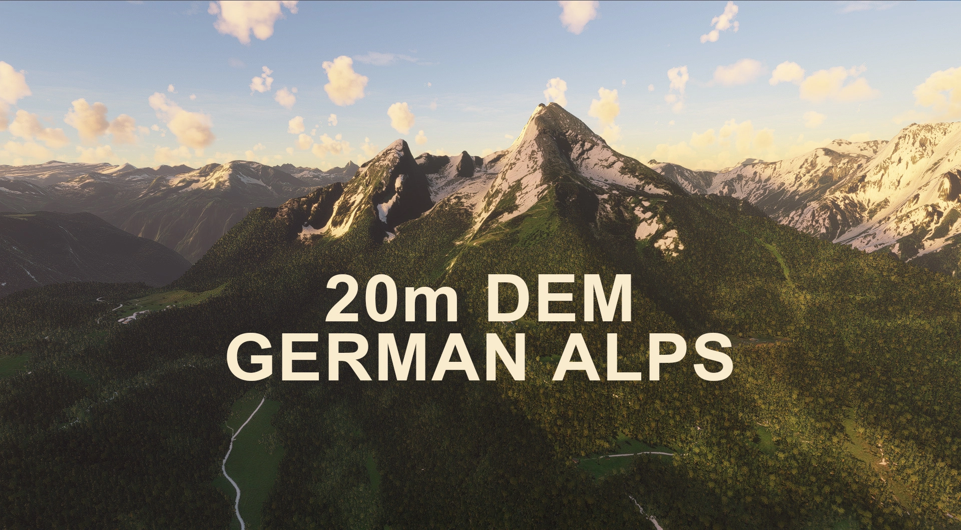
Description
This mod contains customized height profiles for the German Alps. The mod contains high definition LIDAR DEM data with a mesh resolution of 20m, whereas the MSFS uses a lateral resolution of about 50m or worse. The height resolution is as good as 0.1m. I tried to compile the whole German DEM, but the filesizes where to big to compile. Maybe I will do a DEM broken down into the German Sub-States at a later point.
The mod does not only provide mountain shapes being very close to reality, but also flattens lakes & rivers and gets rid of any terrain artifacts.
Disclaimer: The creator of this mod is not responsible for any problems, damage, incompatibilites to other mods or performance issues that might occur.
Please note, that this mod is a high resolution mesh covering a large area of southern Germany. The elevation data is applied through terraforming rectangles, thus loaded at a certain distance from the player. When travelling fast or at high alitude (wide range of view) there might be too many new rectangles loaded simultaneously and thus stutters might occur.
If you have any stutters you can try and reduce your ingame render settings or uninstall!
If you are mainly flying airliners in high altitude, there is probably no benefit for you in using this mod.
Any large Payware and Freeware Airport I could think of, has been excluded from the mesh. So hopefully the glitches will be minimal.
Please report any bugs with sceneries or airports and I will see what I can do!
The elevation data used was a LIDAR 20m height profile of Germany compiled by Sonny (http://data.opendataportal.at/dataset/6cc1f714-dff8-415e-8655-11b4e462ea52)
It was then transfered into MSFS using MSFS Toolkit by Nool Aerosystems (https://msfs.nool.ee/)
Thank you both and for anyone reading this: Please go ahead and support them!
Enjoy your VFR flights above the German Alps!
Commentaires(49)
Connectez-vous pour participer à la discussion
Se connecteralmost 4 years ago
SU9?
about 4 years ago
Is it normal y that i have a massive FPS drop
?
over 4 years ago
I realized that with one of the recent MSFS updates quite some stutter had been introduced with either this addon or the Swiss or Austrian variant.
over 4 years ago
Thank you for your comment. Indeed, all DEMs are currently compromised. I am puzzled for the reason though and working on a fix.
almost 4 years ago
Did you find the cause of this Troglodytus?
Would be a shame if this great meshs wouldn't work any more... :(
over 4 years ago
Hallo
ich nutze die Alpen Meshes regelmäßig weil es die Darstellung der Alpen m.E. erheblich verbessert und möchte mich dafür bedanken. Leider gibt es ein Problem mit den Aersoft Bavarian Airfields und zwar bei Kempten. Dort bildet sich (nur wenn ich das Mesh benutze) ein ca. 2 m hoher jedenfalls für Flugzeuge unüberwindlicher Absatz im Bereich des Vorfeldes. Es wäre schön wenn man das Problem lösen könnte. Ich habe Aerosoft auch darüber informiert.
Mit freundlichen Grüßen
Uwe Zander
over 4 years ago
Vielen Dank für die Mitteilung. Leider war es mir nicht möglich von Vornherein alle Flugplätze auszusparen und einzeln zu bearbeiten, ich werde das aber nachliefern, sobald ich die Zeit dafür finde!
over 4 years ago
Grandios; vielen Dank für die prompte Antwort.
over 4 years ago
When are you planning to do the rest of Germany? Not every area got new dem with the world update. Especially the south is very mountainous and therefore pretty important. Please man you are my only hope to get good dem for these areas.
almost 5 years ago
https://abload.de/img/2021-09-0910_17_02-20bmjs7.png
to the left, this 20m DEM, to the right, the alps after world update 6.
As you can see, this 20m DEM from Troglodytus is still relevant and important.
In case u wondered..
almost 5 years ago
Thank you very much! There is still an update incoming, for the DEMs, to exclude new photogrammetry areas.
almost 5 years ago
Perfecto, i am also following the discussions that you had with one fellow flightsimmer on the world update and the austria dem. while i dont know about the changes in austria and switzerland by the world update, i still prefer to continue using your "encyclopedia of DEMs", especially because i like to have smooth transitions between the countries (which i bet you took care of) and also since i love flying in the dolomites and with world update data, the 3 Peaks of Lavaredo don't even exist in a recognizable form :) Keep up the good work man
about 5 years ago
Awesome addon. Worked great until now.
Unfortunately with the latest sim update I have the issue that the photogrametry in Munich is broken when I have this addon installed. That’s a real shame.
Anyone else with this issue?
about 5 years ago
Excuse my lack of knowledge but I was wondering if anyone would have a flight plan so I could enjoy this scenery. I don't want to do a point A to point B flight and only see a little bit. Thank you
about 5 years ago
Hallo/Hello! first of all thanks for all your great scenery stuff! excellent work!
unfortunately i have the following issue which has may be discussed previously, but havent found a solution for "border issues".
if i have both the austria-salzburg DEM and the german-alps DEM installed, there are artifacts north of salzburg (LOWS) airport (undefined steep sharp hills/mountains in regions where there are actually no hills or mountains in reallife). if i run either austria DEM -OR- the german DEM, everything is fine. the issue just occurs when there are both DEMs. i tried to put "z" in front of the austria DEM folder in order to load it after the german DEM, and therefor give the austria DEM a higher priority, but this does not work.
any hints appreciated. thanks
about 5 years ago
Can you fix the elevation points for EDNL with this mod installed?
https://de.flightsim.to/file/11112/ednl-airfield-leutkirch
For example, when I look at the grass taxiways after installing the DEM package, they are no longer leveled like in real. :)
Would be nice!
about 5 years ago
That airfield should already be excluded, asI excluded all payware airfieldy available in that region.
will doublecheck though.
about 5 years ago
These are absolutely brilliant! I love the work y'all are doing! Are you guys going to venture into the United States by chance? I would love to see the Rocky Mountains in Colorado up to Montana given some love!
about 5 years ago
Thanks very much! I honestly believe that the US have one of the most detailed meshes to date. Ever since World Update 2, Asobo have updated the data. Non the less, eventually I'd like to update the Rockies, lets see!
GERMAN ALPS 20m DEM - High Resolution Terrain Elevation Data from LIDAR Imaging
Explore the beauty of the German Alps with this mod featuring high-resolution terrain elevation data from LIDAR imaging. The customized height profiles offer a mesh resolution of 20m, providing mountain shapes close to reality and smoothing out lakes, rivers, and terrain artifacts. Experience immersive VFR flights with improved elevation detail in southern Germany.

Avis des utilisateurs
9 avis
Location
More Information
Historique des versions
Since World Update 6, the generic mesh data is really high quality. However, here is a short pro and con list for the use of this Addon: CON * Default mesh is now higher quality, when being very close to the ground/mountains PRO * The mountains still look better from far away, as the LOD scaling is very different. Default mountains get round at a certain distance * This mod does not cause "pop ins" of high quality when flying close to mountains. Changes v1.2: * Excluded greater Munich area because of conflicts with Photogrammetry * Excluded areas include EDNX Schleissheim and OBF Oberpfaffenhofen * Recompiled with new algorithm * Adjusted falloff distance for better blending with surrounding areas
Similaires

Swiss mountains tree fix (trees on mountains removed)
A comprehensive mod fixing tree placement on Swiss mountains, particularly removing inaccurately placed trees on mountain peaks. The update includes a shift to more realistic conifer trees in the Alps and an expansion to border areas of France, Italy, and Austria. From Alpstein Säntis to Stockhorn, numerous locations across Switzerland have been meticulously corrected for a more authentic flight experience.
par THEOLI4D

Shorter Trees / Tree Height Modification VERSION 4.0 for MFS2020 (shorter, realistic trees)
Experience realistic and shorter trees in Microsoft Flight Simulator with the Shorter Trees / Tree Height Modification VERSION 4.0 add-on. Compatible with the latest version of MSFS, this mod provides adjusted tree heights for a more authentic flying experience. Update includes enhanced tree coloration blending seamlessly with photogrammetry trees. Installation is simple - just copy the folder into your community folder and enjoy a new perspective from the skies.
par ARIF STUDIOS - Adnan Arif

AUSTRIA 10m DEM - High Resolution Terrain Elevation Data from LIDAR Imaging
Explore the stunning terrain of Austria with this mod featuring high-resolution LIDAR data, offering a mesh resolution of 10m for a more realistic flight experience. Flatten lakes, rivers, and eliminate any terrain artifacts as you soar over the Austrian landscape. Divided into regions for convenience and performance optimization, this mod enhances the mountain shapes to mirror reality and provides a smoother flying experience. Experience Austria like never before with enhanced elevation data and realistic terrains.
par Troglodytus

SWITZERLAND 20m DEM - High Resolution Terrain Elevation Data from LIDAR Imaging
Explore the beauty of Switzerland with this mod offering high resolution terrain elevation data using LIDAR imaging. The mesh resolution is 20m, providing exceptional detail with a height resolution of 0.1m. Update includes extreme LIDAR meshes for specific regions. Please note potential performance impacts and report any bugs for further improvements. Fly VFR over Switzerland with enhanced realism and accuracy.
par Troglodytus
7 months ago