Description
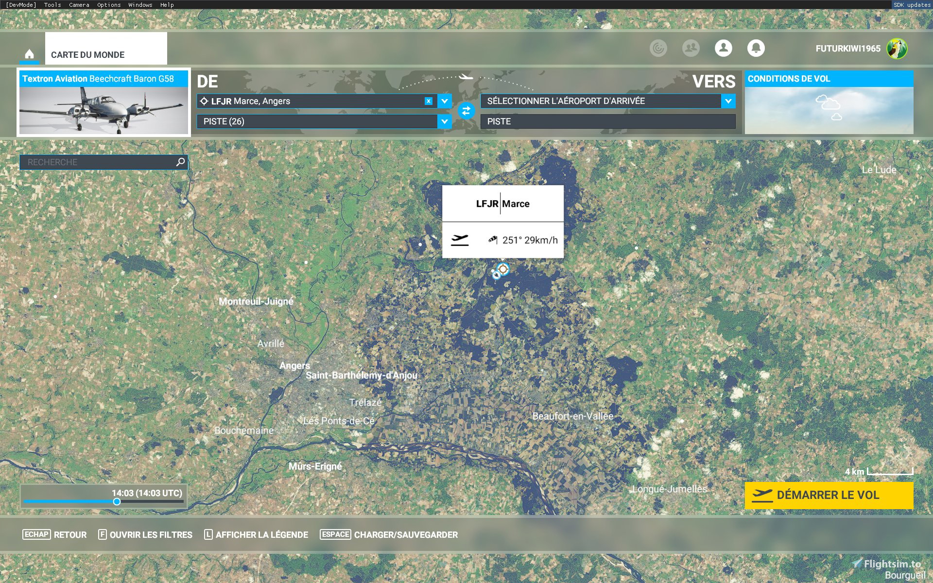
LFJR - ANGERS/Marcé - Aerial 1M - East Maine-et-Loire - 02
Aerial 1 meter resolution (LOD 17) for the eastern part of the Maine-et-Loire department suffering from the BingMap texture shift.
Source: BD, ORTHO®, OpenData, IGN.
Removed auto-generated houses on the offset BingMap map.
Removed the native vegetation on the offset BingMap texture and replaced it with vegetation polygons from the TOPO® OpenData IGN database.
Colorometric correction for better integration with ANGERS of the City update II.
Optional for LFJR - ANGERS/Marcé - Airport.
Download only the main file because there is a bug on the site that does not allow you to delete the old secondary files.
Thanks to:
Microsoft Asobo
Arno Gerretsen
MSFS Toolkit by Nool Aerosystems
Copyright: ftsxlw ftsx.free.lw@gmail.com
Exclusively for free distribution and subject to the express permission of the author.
============================================================================================================================================================================================================================================
LFJR - ANGERS/Marcé - Aerial 1M - East Maine-et-Loire - 02
Aerial 1 mètre de résolution (LOD 17) pour la partie Est du département du Maine-et-Loire souffrant du décalage de la texture BingMap.
Source BD ORTHO® OpenData IGN.
Suppression des maisons auto générées sur la texture BingMap décalée.
Suppression de la végétation native sur la texture BingMap décalée et remplacement par les polygones de végétations issues de la BD TOPO® OpenData IGN.
Correction colorométrique pour une meilleure intégration avec ANGERS de la City update II.
Optionnel pour LFJR - ANGERS/Marcé - Airport.
Ne télécharger que le fichier principal parce qu'il y a un bug du site qui ne permet pas de supprimer les anciens fichiers secondaires.
Merci à :
Microsoft
Asobo
Arno Gerretsen
MSFS Toolkit by Nool Aerosystems
Copyright : ftsxlw
ftsx.free.lw@gmail.com
Exclusivement pour diffusion gratuite et soumise à autorisation expresse de l’auteur.
Commentaires(8)
Connectez-vous pour participer à la discussion
Se connecterabout 4 years ago
ouah ! pas top ça. impossible de deconpresser 1 dossier il manque tjrs un alors que j 'ai tout telecharger;
je ne sais pas comment les autres ont fait...
c 'est le cirque complet !
about 4 years ago
Bonjour !
Je viens de vérifier l'intégrité des fichiers à télécharger et un fichier .RAR sur le téléchargement de la PART03 était abimé ! Cela arrive quelquefois sur les gros fichiers et c'est indépendant de ma volonté, peut-être un problème sur le serveur de Flightsim.to.
Concernant ce que vous appelez un "souk", il est certain qu'il faut être un tant sans peu méthodique avec l'obligation de Flightsim.to de limiter les fichiers à 2Go.
Je récapitule les fichiers à télécharger:
LFJR - ANGERS/Marcé - PART01-A : 1 fichier .RAR -> 01-france-dpt-49-ftslw-lfjr-02-airport-0.9.96_rUT3W.rar. Ce fichier en décompression unique vous donnera le répertoire: 01-france-dpt-49-ftslw-lfjr-02-airport-0.9.96
LFJR - ANGERS/Marcé - PART01-B : 2 fichiers .RAR -> 01-france-dpt-49-ftslw-lfjr-aerial-hr-0.9.95.part1_tvG8h.rar et 01-france-dpt-49-ftslw-lfjr-aerial-hr-0.9.95.part2_E3pFd.rar. Ces fichiers, liés en décompression, vous donneront les répertoires: 01-france-dpt-49-ftslw-lfjr-01-noveg-0.9.95 et 01-france-dpt-49-ftslw-lfjr-aerial-hr-0.9.95
------------------------------------------------------------------------------------
LFJR - ANGERS/Marcé - PART02 : 1 fichier .RAR -> france-dpt-49-ftslw-lfjr-aerial01-1m-0.9.6.part1.rar
LFJR - ANGERS/Marcé - PART03 : 2 fichiers .RAR -> france-dpt-49-ftslw-lfjr-aerial01-1m-0.9.6.part2.rar et france-dpt-49-ftslw-lfjr-aerial01-1m-0.9.6.part3.rar
LFJR - ANGERS/Marcé - PART04 : 1 fichier .RAR -> france-dpt-49-ftslw-lfjr-aerial01-1m-0.9.6.part4.rar
Les fichiers des PART02; 03 et 04 sont tous liés en décompression et il vous donneront les répertoires suivants:
france-dpt-49-ftslw-lfjr-aerial01-1m-0.9.6
france-dpt-49-ftslw-lfjr-aerial02-1m-0.9.6
france-dpt-49-ftslw-lfjr-aerial03-1m-0.9.6
france-dpt-49-ftslw-lfjr-aerial04-1m-0.9.6
Si c'est le fichier abimé de la Part03 qui vous a causé vos soucis, merci de m'avoir alerté !
over 4 years ago
le part 3 charge le part 4 c'est le souk
over 4 years ago
Bonjour, je vous ai répondu en privé, mais bon désolé, c'est pas moi qui fait le débit internet !!
over 4 years ago
I cannot find france-dpt-49-ftslw-lfjr-aerial-1m-0.9.6.part1 france-dpt-49-ftslw-lfjr-aerial-1m-0.9.6.part2 and france-dpt-49-ftslw-lfjr-aerial-1m-0.9.6.part3. The files in here are 4, 5, and 6 only.
LFJR - ANGERS/Marcé - Aerial 1M - East Maine-et-Loire - 02
Aerial 1-meter resolution add-on covering eastern Maine-et-Loire, enhancing scenery with corrected BingMap textures, removed auto-generated content, and improved vegetation integration from TOPO database. Complements LFJR - ANGERS/Marcé Airport and includes colorometric adjustments for ANGERS City update II. Developed with contributions from Microsoft Asobo and MSFS Toolkit.
Avis des utilisateurs
1 avis
Location
More Information
Historique des versions
Similaires

Swiss mountains tree fix (trees on mountains removed)
A comprehensive mod fixing tree placement on Swiss mountains, particularly removing inaccurately placed trees on mountain peaks. The update includes a shift to more realistic conifer trees in the Alps and an expansion to border areas of France, Italy, and Austria. From Alpstein Säntis to Stockhorn, numerous locations across Switzerland have been meticulously corrected for a more authentic flight experience.
par THEOLI4D

Shorter Trees / Tree Height Modification VERSION 4.0 for MFS2020 (shorter, realistic trees)
Experience realistic and shorter trees in Microsoft Flight Simulator with the Shorter Trees / Tree Height Modification VERSION 4.0 add-on. Compatible with the latest version of MSFS, this mod provides adjusted tree heights for a more authentic flying experience. Update includes enhanced tree coloration blending seamlessly with photogrammetry trees. Installation is simple - just copy the folder into your community folder and enjoy a new perspective from the skies.
par ARIF STUDIOS - Adnan Arif

AUSTRIA 10m DEM - High Resolution Terrain Elevation Data from LIDAR Imaging
Explore the stunning terrain of Austria with this mod featuring high-resolution LIDAR data, offering a mesh resolution of 10m for a more realistic flight experience. Flatten lakes, rivers, and eliminate any terrain artifacts as you soar over the Austrian landscape. Divided into regions for convenience and performance optimization, this mod enhances the mountain shapes to mirror reality and provides a smoother flying experience. Experience Austria like never before with enhanced elevation data and realistic terrains.
par Troglodytus

SWITZERLAND 20m DEM - High Resolution Terrain Elevation Data from LIDAR Imaging
Explore the beauty of Switzerland with this mod offering high resolution terrain elevation data using LIDAR imaging. The mesh resolution is 20m, providing exceptional detail with a height resolution of 0.1m. Update includes extreme LIDAR meshes for specific regions. Please note potential performance impacts and report any bugs for further improvements. Fly VFR over Switzerland with enhanced realism and accuracy.
par Troglodytus
over 2 years ago
L'installation est excessivement compliquée à cause de l'extraction multiple. Les fichiers CGL étant énormes et peu compressibles (probablement déjà compressés), il aurait été plus simple d'uploader des fichiers indépendants vers un cloud, du genre Mega, par exemple (20go gratuits).. Certains développeurs pratiquent déjà ce système.