
Description
Le Mont Bessou est un sommet du Massif central, situé sur la commune de Meymac, en Corrèze.
Avec 977 m d'altitude, c'est le point culminant du plateau de Millevaches.
GPS : 45.57044, 2.12308
INSTALLATION :
Supprimer l' ancien dossier si nécessaire.
Copiez dans le dossier community.
Bons vols.
Vous pouvez aussi laisser un commentaire et ou mettre une note, c' est encourageant pour continuer, merci.
Michel
---------------------------------------------------------------------
Mont Bessou is the highest point of the Plateau De Millevaches
GPS : 45.57044, 2.12308
INSTALLATION :
Remove old folder if present.
Drop in your community folder.
You can also leave a comment or put a note, it's always nice and encourages for a new scene, thank you.
Enjoy it.
Michel
Commentaires(6)
Connectez-vous pour participer à la discussion
Se connecteralmost 5 years ago
Merci, beaucoup.
almost 5 years ago
Parfait, je ne connaissais pas cet endroit, ce sera l'occasion d'aller voir, merci. ;)
almost 5 years ago
Ah super !!! Merci beaucoup ! Il y aurai moyen de rajouter la tour panoramique ?
almost 5 years ago
Merci, oui c' est en projet puisque ça plait.
almost 5 years ago
Chouette ...!!!
Mont Bessou
Explore the highest point of the Plateau De Millevaches with Mont Bessou, located in Meymac, Corrèze, with an altitude of 977m. Enhance your virtual flying experience with this scenic add-on in Microsoft Flight Simulator.

Avis des utilisateurs
4 avis
Location
More Information
Historique des versions
New meshes for better visibility.
Présent dans des collections(1)
Similaires
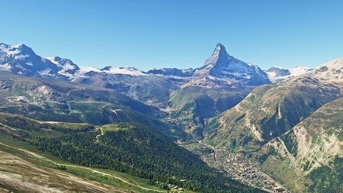
Matterhorn Mountain
Explore the stunning beauty of Matterhorn mountain with this add-on, featuring a fully photogrammetry-based model and terraformed edges for a more realistic experience. Version 2.0 includes new additions such as improved LOD levels, color-corrected textures, cable car pylons, and populated forests. Install by dragging the folder into your "Community" folder and enjoy the enhanced scenery around this iconic peak.
par NikPrist
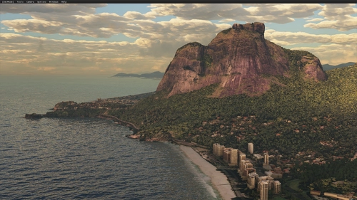
Rio de Janeiro Megapack Montanhas
Explore the detailed mountainous landscape of Rio de Janeiro in this updated megapack. Precisely positioned mountains like Pedra da Gávea and Pão de Açúcar using Google Maps models. Create your mod via Earth2MSFS for an effective import process. Stay tuned for further updates with optimized textures and added landmarks. Individualize your experience by adding specific mountain ranges to enhance your simulation.
par RodrigoMoraes94
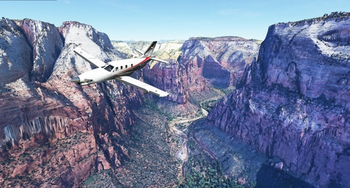
Zion Canyon National Park, Utah
Explore the breathtaking beauty of Zion Canyon National Park in Utah with this V1.0 scenery add-on. Discover well-known locations like the Zion Canyon Overlook, Angels Landing, and more. Experience corrected terrain heights and improved color blending for a more immersive flight simulation. Simply extract the file to your Community Folder and start your aerial adventure in this stunning national park.
par Jeppeson2001
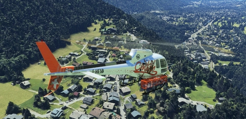
Chamonix-Mont-Blanc, Rhône-Alpes, France - Valley
Explore the stunning Chamonix-Mont-Blanc valley in Rhône-Alpes, France with this addon, including a semi-fictional DZ at Argentière. Enhance your experience by combining it with the Mountains addon. Download, extract into community folder, and enjoy photogrammetry and object data. This addon requires a minimum configuration for optimal performance.
par AdrianL
over 2 years ago