Flightsim.to
    Mont Aigoual with Helipads - Image 1

    Description

    Le Mont Aigoual est un sommet au bord du sud du Massif central, situé sur la commune de Valleraugue dans le Gard et à la limite de la Lozère.

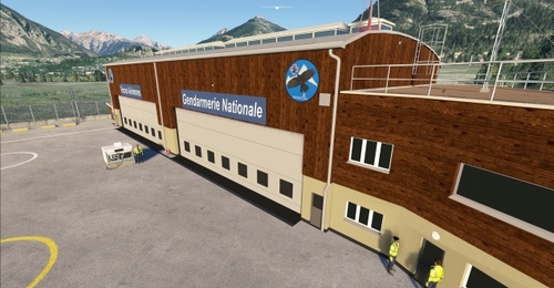
    A 1565 m d'altitude, se trouve une station météo de montagne, construite à partir de 1887.

    Depuis  septembre 2021, il y a des travaux d' agrandissement côté est donc le site n' est déjà plus comme je l' ai représenté.

    GPS : 44.121210, 3.581450

    Ajout du :

    MÉMORIAL DU MAQUIS AIGOUAL-CÉVENNES, COL DU PAS (GARD)

    6 kilomètres à l'est sud-est

    GPS : 44.105900, 3.653510

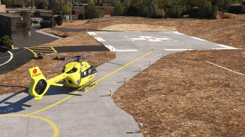
    Les helipads sont à 44.121260, 3.581339 et 44.121514, 3.581344.

    INSTALLATION :

    Eventuellement supprimer l' ancien dossier.

    Copiez dans le dossier community.

    Bons vols.

    Vous pouvez aussi laisser un commentaire et ou mettre une note, c' est encourageant pour continuer, merci.

    Michel

    ---------------------------------------------------------------------
    https://www.aigoual.asso.fr/

    http://www.accac.eu/Gestion_des_depenses_publiques_en_Cevennes.htm/Meteo-site-Observatoire-Aigoual.htm

    http://museedelaresistanceenligne.org/media8010-MA
    ---------------------------------------------------------------------

    Mont Aigoual is a highest point of south Massif Central with an old meteo station still working since 1887.

    GPS : 44.121210, 3.581450

    Helipads are at 44.121260, 3.581339 and 44.121514, 3.581344.

    Added :

    MÉMORIAL DU MAQUIS AIGOUAL-CÉVENNES, COL DU PAS (GARD)

    3.7 mi at the east south-east

    GPS : 44.105900, 3.653510

    Helipads are at 44.121260, 3.581339 and 44.121514, 3.581344.

    INSTALLATION :

    Delete old file if necessary.

    Drop in your community folder.

    You can also leave a comment and or put a note, it's always nice and encourages for a new scene, thank you.

    Enjoy it.

    Michel


    Commentaires(14)

    Connectez-vous pour participer à la discussion

    Se connecter
    a

    over 2 years ago

    Super merci pour cette maj cool les dz sur les mats !
    K

    over 4 years ago


    a

    over 4 years ago

    Juste une petite question !

    sur les bâtiments il y a deux piliers avec une plate forme circulaire , serait possible de les rendre landables avec un hélico un joli défis à faire ;o)

    m
    michelvpAuthor

    over 2 years ago

    c' est fait
    a

    over 4 years ago

    merci pour la MAJ !

    p

    over 4 years ago

    Super, c'est par chez moi. Par contre c'est pas le Massif Central ^^

    Merci pour ce beau travail

    m
    michelvpAuthor

    over 4 years ago

    Effectivement à quelques mètres près puisque la Lozère en fait partie.

    k

    over 4 years ago

    Si je peut me permettre une petite remarque sur la présentation

    ce n’est pas la seule station météo de montagnes (ni la première) 😉

    m
    michelvpAuthor

    over 4 years ago

    Merci, oui en effet j' aurais du préciser "habitée", mais je suis preneur d' autres précisions sur les stations météo de montagne pour mettre ma description à jour.

    k

    over 4 years ago

    Regarde par exemple le pic du midi de Bigorre dont la première vocation a été la météorologie et l’est toujours d’ailleurs mais il c’est étoffé avec l’astronomie et est habité à l’année aussi .

    m
    michelvpAuthor

    over 4 years ago

    Merci de ces précisions pour ce site habité par des astronomes.

    L

    over 4 years ago

    Super ! Merci de Montpellier

    a

    over 4 years ago

    merci pour la réalisation je l attendais .avec le R44 cela va être une belle sortie .

    V

    over 4 years ago

    Super, j'y cours, plutôt j'y vole!

    MSFS 2020MSFS 2024

    Mont Aigoual with Helipads

    Explore the stunning Mont Aigoual with helipads in this detailed add-on. Discover the historic meteo station at 1565m altitude, along with a new memorial site nearby. With precise GPS coordinates and easy installation instructions, embark on a scenic flight experience at this iconic location.

    Téléchargements2K
    Version1.30
    Taille du fichier1.85 MB
    PubliéIl y a 4 ans
    Mis à jourIl y a 2 ans

    Avis des utilisateurs

    5.0

    4 avis

    5
    100%
    4
    0%
    3
    0%
    2
    0%
    1
    0%

    More Information

    Simulateur
    MSFS2020/24
    Sub-CategoryMountains
    PaysFrance
    ICAONULL

    Historique des versions

    New meshes for better visibility. Terraforming is corrected and Memorial Col Du Pas is back.

    Similaires

    Matterhorn Mountain

    Matterhorn Mountain

    Explore the stunning beauty of Matterhorn mountain with this add-on, featuring a fully photogrammetry-based model and terraformed edges for a more realistic experience. Version 2.0 includes new additions such as improved LOD levels, color-corrected textures, cable car pylons, and populated forests. Install by dragging the folder into your "Community" folder and enjoy the enhanced scenery around this iconic peak.

    par NikPrist

    4.9
    Rio de Janeiro Megapack Montanhas

    Rio de Janeiro Megapack Montanhas

    Explore the detailed mountainous landscape of Rio de Janeiro in this updated megapack. Precisely positioned mountains like Pedra da Gávea and Pão de Açúcar using Google Maps models. Create your mod via Earth2MSFS for an effective import process. Stay tuned for further updates with optimized textures and added landmarks. Individualize your experience by adding specific mountain ranges to enhance your simulation.

    par RodrigoMoraes94

    4.7
    Zion Canyon National Park, Utah

    Zion Canyon National Park, Utah

    Explore the breathtaking beauty of Zion Canyon National Park in Utah with this V1.0 scenery add-on. Discover well-known locations like the Zion Canyon Overlook, Angels Landing, and more. Experience corrected terrain heights and improved color blending for a more immersive flight simulation. Simply extract the file to your Community Folder and start your aerial adventure in this stunning national park.

    par Jeppeson2001

    4.7
    Chamonix-Mont-Blanc, Rhône-Alpes, France - Valley

    Chamonix-Mont-Blanc, Rhône-Alpes, France - Valley

    Explore the stunning Chamonix-Mont-Blanc valley in Rhône-Alpes, France with this addon, including a semi-fictional DZ at Argentière. Enhance your experience by combining it with the Mountains addon. Download, extract into community folder, and enjoy photogrammetry and object data. This addon requires a minimum configuration for optimal performance.

    par AdrianL

    4.3