Description
This one is a different area for a change.
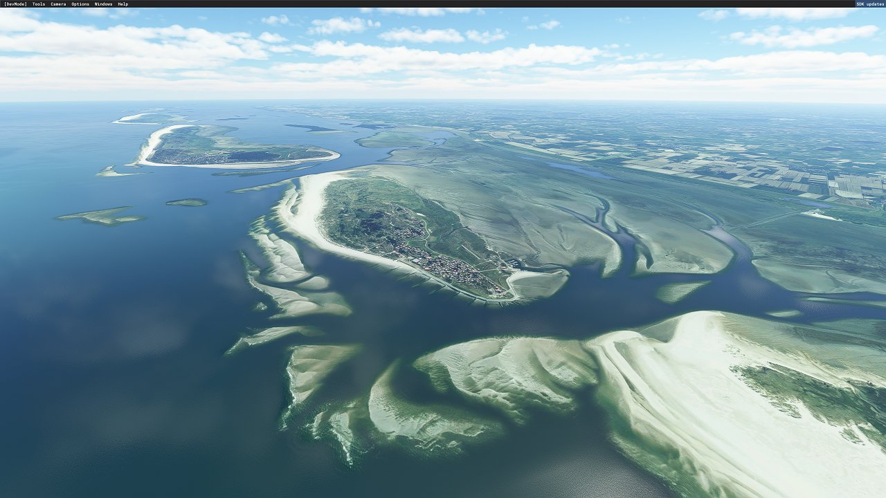
A user requested the East Frisian Islands so I had a quick look to see what could be done.
Unfortunately there isn't a lot of Bing imagery that could be used inbetween the islands and what could be used appears to be of slightly less resolution than the UK imagery but I was able to reveal some Sandbanks which I think lifts the appearance over the stock water level and shorelines.
Once new Bing imagery becomes available and is implimented in the sim I may be able to improve on this area - this will also be the case for my other Sandbank mods.
For installation extract the included folder called " mgk07-frisian-islands" into your MSFS Community folder.
Check out my other sandbank mods here: https://flightsim.to/profile/mgk07/uploads
Thanks,
Mark.
Commentaires(19)
Connectez-vous pour participer à la discussion
Se connecteralmost 2 years ago
I mean the area between the triangle of Spiekeroog-Wangerooge- Harlesiel.
Thanks!
over 2 years ago
over 4 years ago
Wow what a gread mod!!!! Thanks!! I enjoy the East Frisian Island, but, being dutch, could you also do the "Waddenzee", that is the sea between the Dutch Islands (Waddeneilanden) and the main land.
over 4 years ago
Thanks. I think there is already decent watermasks around the islands off the Dutch coast, it seems ASOBO added them there but not for the East Islands. I’ll take a look and see if anything can be done anyway to add sandbanks.
over 4 years ago
Looks great! Is there a conflict between your mod and his mod here:
https://flightsim.to/file/25135/frisian-islands-sand-banks
?
over 4 years ago
Possibly - I think they will both be trying to do the same thing (using exclusion polygons) I recommend only using one or the other.
over 4 years ago
hello
that is a good question
I really don't know if there is any conflict
maybe you should give it a try, and tell me
best regards
over 4 years ago
Realy beautifull scenery addon, works great in tandem with the Frysian islands west. Thanks a lot!
over 4 years ago
The islands look interesting by default, but at low tide, the sand banks add so much more character. This mod is compatible with the payware East Frisan package, also with all of the freeware mods for the area that I've accumulated over the last year (thanks .to!!!). Very, very highly recommended!
over 4 years ago
It's gorgeous!
What a treat! Thank you!
over 4 years ago
Hello Mark. Well, that was really fast.😍
Thank you so much! I sent you a small donation via PayPal.
The mod is superb. The sandbanks look quite realistic. Wonderful!
I also tested the compatibility with "Aerosoft Airfields East Frisian Islands" and the "Langeoog Scenery Enhancement" mod. All three mods seem compatible with each other (so far I have only tested at the coast of Langeoog Island).
over 4 years ago
Hi Daniel, thank you for your support it is really appreciated. 🙏
I am glad you like the mod and that it appears to be working well with other mods. Thank you for confirming that so far.
if I’m able to update this mod further in the future I’ll be sure to do so.
Happy flying :)
over 4 years ago
Bonjour, merci pour ce travail. Il y a t il compatibilité avec AEROSOFT EastFrisanIslands ( EDWR-J-Y-Z-L-G aerosoft )
merci
over 4 years ago
Hello, sorry I don’t have that add on so cannot test or confirm for you but I would imagine that if there are no custom exclusion zones for the sea with the Aerosoft Frisian Islands Airfields add on then I don’t see why the two shouldn’t get along nicely.
If someone is able to test this and confirm that would be a great help.
Thank you.
Mark.
over 4 years ago
Your Sand Banks work great with the East Frisian payware mod. I just flew the islands last night and everything works seamlessly together.
over 4 years ago
That’s good to hear thank you for letting me know.
East Frisian Islands Sandbanks
Explore the Sandbanks of the East Frisian Islands with this unique mod. Enhance your sim experience with improved water levels and shorelines in this requested area. Stay tuned for updates as new Bing imagery may further enhance this add-on. Simply extract the folder into your MSFS Community folder to enjoy the visual improvements.

Soutiens
Avis des utilisateurs
7 avis
Location
More Information
Historique des versions
Aucun historique de version disponible.
Similaires

Swiss mountains tree fix (trees on mountains removed)
A comprehensive mod fixing tree placement on Swiss mountains, particularly removing inaccurately placed trees on mountain peaks. The update includes a shift to more realistic conifer trees in the Alps and an expansion to border areas of France, Italy, and Austria. From Alpstein Säntis to Stockhorn, numerous locations across Switzerland have been meticulously corrected for a more authentic flight experience.
par THEOLI4D

Shorter Trees / Tree Height Modification VERSION 4.0 for MFS2020 (shorter, realistic trees)
Experience realistic and shorter trees in Microsoft Flight Simulator with the Shorter Trees / Tree Height Modification VERSION 4.0 add-on. Compatible with the latest version of MSFS, this mod provides adjusted tree heights for a more authentic flying experience. Update includes enhanced tree coloration blending seamlessly with photogrammetry trees. Installation is simple - just copy the folder into your community folder and enjoy a new perspective from the skies.
par ARIF STUDIOS - Adnan Arif

AUSTRIA 10m DEM - High Resolution Terrain Elevation Data from LIDAR Imaging
Explore the stunning terrain of Austria with this mod featuring high-resolution LIDAR data, offering a mesh resolution of 10m for a more realistic flight experience. Flatten lakes, rivers, and eliminate any terrain artifacts as you soar over the Austrian landscape. Divided into regions for convenience and performance optimization, this mod enhances the mountain shapes to mirror reality and provides a smoother flying experience. Experience Austria like never before with enhanced elevation data and realistic terrains.
par Troglodytus

SWITZERLAND 20m DEM - High Resolution Terrain Elevation Data from LIDAR Imaging
Explore the beauty of Switzerland with this mod offering high resolution terrain elevation data using LIDAR imaging. The mesh resolution is 20m, providing exceptional detail with a height resolution of 0.1m. Update includes extreme LIDAR meshes for specific regions. Please note potential performance impacts and report any bugs for further improvements. Fly VFR over Switzerland with enhanced realism and accuracy.
par Troglodytus
almost 2 years ago
It's just that I'm currently flying around Normandy in France, which got good water mask treatment in some upgrade, showcasing just how big the effect of correct "wetness" is.
Great work nontheless, just an idea I had