Description
This one wasn't quite finished and just when I was putting the finishing touches to it I lost all the SDK project files due to a crash in Microsoft Flight Simulator. It was 95% complete so I have decided to release as is in the hope it provides some improvement over the default coastlines in the area. Please note there may be a few trees or rough edges here and there that I didn't get chance to remove but most is complete.
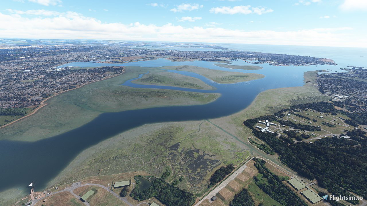
This one coveres the Portsmouth area from Lee-on-the-Solent to Aldwick Beach revealing the sandbanks and marshes where the satalite imagery allows.
For instalation extract the folder "mgk07-portsmouth" into your MSFS community folder.
Check out my other sandbank mods here: https://flightsim.to/profile/mgk07/uploads
Happy Flying,
Mark.
Commentaires(14)
Connectez-vous pour participer à la discussion
Se connecterover 3 years ago
Really good work, I fly out of of Solent a lot so great to have this. However, there's an issue - if you look at the area so the west of EGHF airfield, it's all at low tide whereas everything around it is more like high tide. Also some random trees in the water. Can you fix that?
about 4 years ago
over 4 years ago
Great addon for local GA flying, thanks for making this!
over 4 years ago
Looks really good at 5000' but at ground level or above you can clearly see that these are above water height and they have trees!!!
In Portsmouth Harbour for instance none of these sand banks and silt deposits are above water real World but instead a fathom or two submerged with the exception of Rat Island. It's a pity as I do a lot of low level flying in this area so cannot use this for realism.
Would they be better as water masks? Is that easy to do?
over 4 years ago
They would definitely be better as watermasks yes but it is currently not possible to create your own watermasks within the sim (not properly anyway) so this is kind of a halfway house at the moment until ASOBO allow this feature ( if at all!).
Sometimes its hard to tell if the uncovered area is above water level or just below with really clear and shallow water above it unless you know the area well plus as I said in the description I didn't get chance to finish this properly so this one is "as is" unfortunately.
over 4 years ago
Well, it's a really good effort.
Is there no way to lower the levels of the geography you've created?
over 4 years ago
unfortunately not as all I am doing is creating exclusion zones for water to reveal the hidden satellite imagery below which is directly streamed in the sim using Bing data.
over 4 years ago
Thanks for continuing to release these. Are Devon and Dorset on your To Do list?
over 4 years ago
Thanks it is on the to do list yes so will hopefully get round to it soon 👍
over 4 years ago
Awesome, thanks!
over 4 years ago
One area that really needs doing is the Severn Estuary and Bristol Channel. I like your work and your sandbanks covering S Wales help. Thanks for all your efforts so far.
over 4 years ago
I actually thought the same and went to work on that area a few weeks back but unfortunately the satellite imagery is either taken at full tide or is stitched together images of different tide stages and generic textures so there was literally nothing good to reveal unfortunately.
over 4 years ago
fantastic keep it coming
Portsmouth Sandbanks
Enhance the coastlines near Portsmouth with this add-on that highlights sandbanks and marshes in the area. Despite being 95% complete, some rough edges may remain due to a technical issue during development. Explore the improved scenery from Lee-on-the-Solent to Aldwick Beach, and enjoy a more detailed experience of the region.

Avis des utilisateurs
3 avis
Location
More Information
Historique des versions
Aucun historique de version disponible.
Similaires

Swiss mountains tree fix (trees on mountains removed)
A comprehensive mod fixing tree placement on Swiss mountains, particularly removing inaccurately placed trees on mountain peaks. The update includes a shift to more realistic conifer trees in the Alps and an expansion to border areas of France, Italy, and Austria. From Alpstein Säntis to Stockhorn, numerous locations across Switzerland have been meticulously corrected for a more authentic flight experience.
par THEOLI4D

Shorter Trees / Tree Height Modification VERSION 4.0 for MFS2020 (shorter, realistic trees)
Experience realistic and shorter trees in Microsoft Flight Simulator with the Shorter Trees / Tree Height Modification VERSION 4.0 add-on. Compatible with the latest version of MSFS, this mod provides adjusted tree heights for a more authentic flying experience. Update includes enhanced tree coloration blending seamlessly with photogrammetry trees. Installation is simple - just copy the folder into your community folder and enjoy a new perspective from the skies.
par ARIF STUDIOS - Adnan Arif

AUSTRIA 10m DEM - High Resolution Terrain Elevation Data from LIDAR Imaging
Explore the stunning terrain of Austria with this mod featuring high-resolution LIDAR data, offering a mesh resolution of 10m for a more realistic flight experience. Flatten lakes, rivers, and eliminate any terrain artifacts as you soar over the Austrian landscape. Divided into regions for convenience and performance optimization, this mod enhances the mountain shapes to mirror reality and provides a smoother flying experience. Experience Austria like never before with enhanced elevation data and realistic terrains.
par Troglodytus

SWITZERLAND 20m DEM - High Resolution Terrain Elevation Data from LIDAR Imaging
Explore the beauty of Switzerland with this mod offering high resolution terrain elevation data using LIDAR imaging. The mesh resolution is 20m, providing exceptional detail with a height resolution of 0.1m. Update includes extreme LIDAR meshes for specific regions. Please note potential performance impacts and report any bugs for further improvements. Fly VFR over Switzerland with enhanced realism and accuracy.
par Troglodytus
over 1 year ago
Many thanks
Muleskinner