Description
If you are keen on Microsoft fixing this issue at their end, please vote here:
https://forums.flightsimulator.com/t/water-in-dry-salt-lakes/736413
SU 16 Update
Aaaaaand they’ve done it again! Everything in Mexico larger than a bathtub has now been filled with fake mid-Atlantic abyss water (at least in 2020). I’m not kidding. I mean, I’m sure there’s many enterprising agriculturists in the Sonora and Chihuahua Deserts who built small dams over the years for “just in case” it rains one day, but the likelihood of them ever containing more than a foot of water is somewhere between highly unlikely and zero. Suffice to say that the Bing imagery provided with SU16 does not contain much visual evidence to the contrary.
Fortunately, it’s not all doom and gloom. Thanks to the implementation of more up-to-date OSM (Open Street Map) data in SU16, many of the waterbody outlines are less jagged, so I was able to reinstate the masks in many places. In 2024, with its more nuanced water colours it should make those places look half decent.
So, I’ve gone through my previous work and adjusted them where necessary and cleaned up any obvious newly created larger dry water bodies. I’ve also erased many, many small dams as I came across them, but I certainly haven’t covered the entire 750,563 square miles that is Mexico with a tiny sponge. I’m sorry, I do have a life… Anyway, there’s any easy fix for Asobo to implement: honour the data you have! OSM have fully tagged their hydrology. Tags like “salt” or “intermittent” should simply be ignored when populating the sim. Case closed.
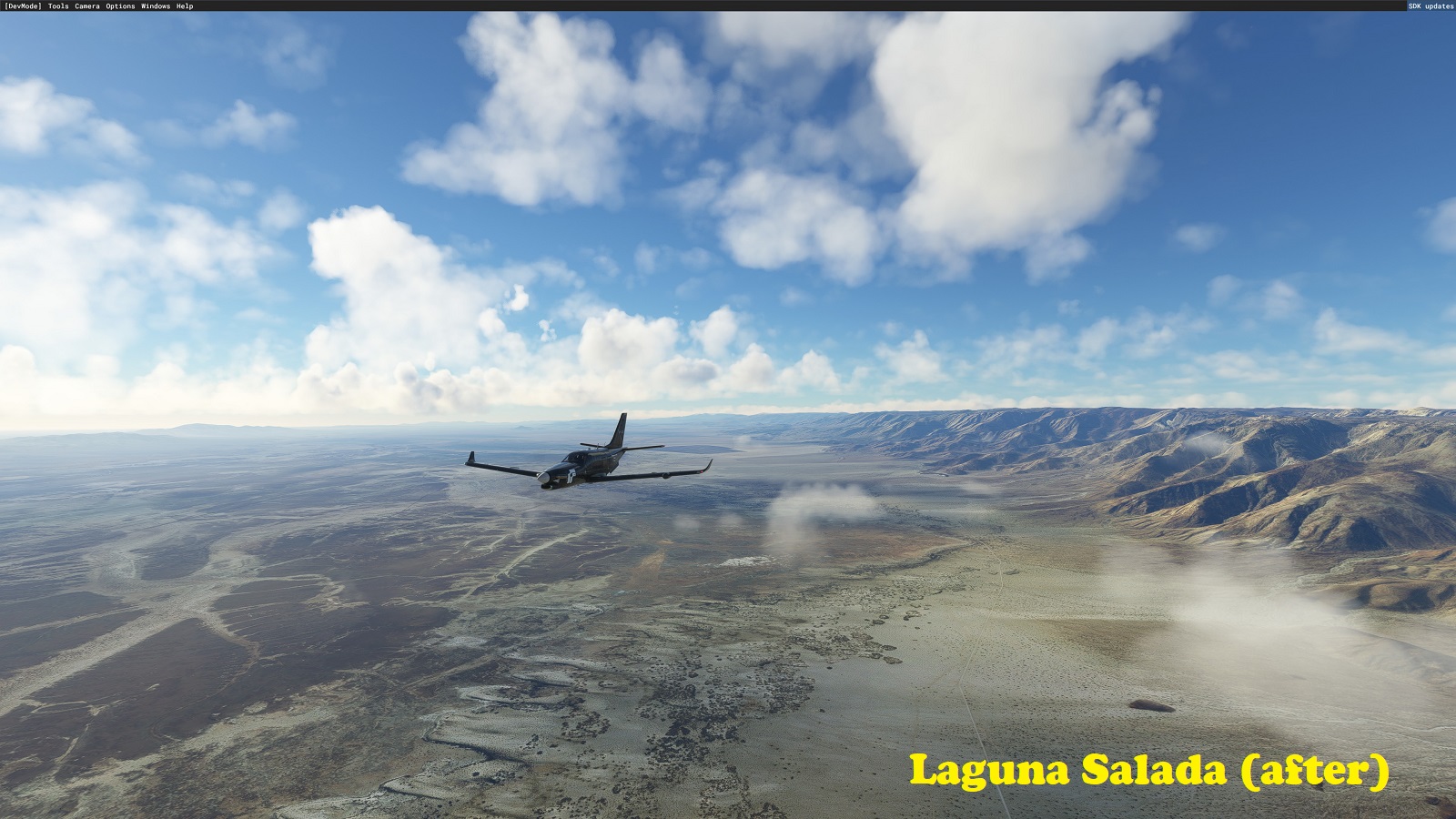
So, I was flying along in northern Baja California the other day, mostly minding my own business and checking out some of the sceneries created by Bozone74, when all of a sudden, I have a rather jarring experience ... there in the middle of what I supposed was the Sonoran Desert lay this beautiful, blue and sparkling lake, basking in the hot Mexican sun! Ooookayyyy!!! Reminded me of something I spent a week of my life fixing recently.
Let's have a closer look then, shall we. What's the name of this thing? Ok, "Laguna Salada" ... the fabled "Salad Lagoon" finally discovered? Probably not, so let's ask Google Translate then. "Laguna" is easy, you guessed it, it means "Lagoon". How about "Salada" then? Well ... it means "SALT"!!! Déjà vu all over again!!! This there blue sparkling lake is not a lake but rather a dry salt "lake".
Anyway, I can't help myself and fix things in MSFS that's either missing (like airfields), or not supposed to be there (like water in dry lakes). This episode covers Mexico...
Notes:
- I've taken a fairly broad brush (or should I say big sponge). There are lots of them (though per capita, not nearly as many as in Australia). If I've missed some, let me know. If I've emptied your favourite dam, let me know.
- The removal of the water has left some of the larger dry lakes with irregular textures (e.g., bad colour correction). It's sometimes noticeable from high altitudes, but this bothers me less than a huge lake where there isn't one.
- I've taken the liberty of also removing the water masks of a lot of dams and small lakes (especially around Mexico City), even if they nominally contained water. However, I've only done so if the default water mask was atrociously bad (unfortunately, many of them are).
- I've left coastal lagoons alone for the most part. The current SDK doesn't have any tools to apply transparent water masks. This means removing water to reveal the rich colours and textures of these coastal lagoons effectively makes them dry land (ie. no float plane-ing etc.). So, until such tools become part of the SDK we're relying on Asobo to apply coastal water masks, which in places like Yucatan and the Gulf of California are painfully overdue.
- There's a mod by timot75 that fixes some of the coastal lagoons in the Gulf of California. There are no issues in using my mod in conjunction with timot75's mod.
[Note: For those geographically and/or geologically minded: Laguna Salada is an endorheic basin (meaning there's no outflow for water, other than evaporation). It's actually a secondary cohort fault of the San Andreas Fault system that's slowly tearing parts of California off continental North America. It's 10 metres below sea level and does occasionally fill with water. However, in the Bing aerial imagery it was clearly dry.]
Commentaires(6)
Connectez-vous pour participer à la discussion
Se connecterover 4 years ago
Thanks man, it sucks flying over over that huge laguna salada desert and see it full of water.
over 4 years ago
Very nice job! Is there any chance you could work your magic for the water errors to the far west of Phoenix, AZ by the White Tank Mountains? There's a stretch west of Luke AFB all the way up to west of Surprise, AZ that's full of water that shouldn't be there. Thanks
over 4 years ago
No worries. Check out this:
https://flightsim.to/file/28456/southwestern-u-s-salt-lakes-fix
over 4 years ago
Thank you very much!
over 4 years ago
Awesome!! This is the place I fly daily. White sands, Yuma & Baja!! Thank you for this!! -Missedapproach
Mexican Salt Lakes Fix
Explore the Mexican Salt Lakes Fix, a mod that rectifies water mask issues in the sim, particularly focusing on dry salt "lakes" like Laguna Salada. This mod aims to enhance the accuracy of the landscape in Mexico by removing misplaced water bodies and irregular textures, providing a more realistic flight experience. Additionally, the mod addresses discrepancies in coastal lagoons while seamlessly complementing other water-fix mods for a comprehensive improvement.

Avis des utilisateurs
1 avis
More Information
Historique des versions
- SU16 update - MSFS 2024 compatibility confirmed
Similaires

Swiss mountains tree fix (trees on mountains removed)
A comprehensive mod fixing tree placement on Swiss mountains, particularly removing inaccurately placed trees on mountain peaks. The update includes a shift to more realistic conifer trees in the Alps and an expansion to border areas of France, Italy, and Austria. From Alpstein Säntis to Stockhorn, numerous locations across Switzerland have been meticulously corrected for a more authentic flight experience.
par THEOLI4D

Shorter Trees / Tree Height Modification VERSION 4.0 for MFS2020 (shorter, realistic trees)
Experience realistic and shorter trees in Microsoft Flight Simulator with the Shorter Trees / Tree Height Modification VERSION 4.0 add-on. Compatible with the latest version of MSFS, this mod provides adjusted tree heights for a more authentic flying experience. Update includes enhanced tree coloration blending seamlessly with photogrammetry trees. Installation is simple - just copy the folder into your community folder and enjoy a new perspective from the skies.
par ARIF STUDIOS - Adnan Arif

AUSTRIA 10m DEM - High Resolution Terrain Elevation Data from LIDAR Imaging
Explore the stunning terrain of Austria with this mod featuring high-resolution LIDAR data, offering a mesh resolution of 10m for a more realistic flight experience. Flatten lakes, rivers, and eliminate any terrain artifacts as you soar over the Austrian landscape. Divided into regions for convenience and performance optimization, this mod enhances the mountain shapes to mirror reality and provides a smoother flying experience. Experience Austria like never before with enhanced elevation data and realistic terrains.
par Troglodytus

SWITZERLAND 20m DEM - High Resolution Terrain Elevation Data from LIDAR Imaging
Explore the beauty of Switzerland with this mod offering high resolution terrain elevation data using LIDAR imaging. The mesh resolution is 20m, providing exceptional detail with a height resolution of 0.1m. Update includes extreme LIDAR meshes for specific regions. Please note potential performance impacts and report any bugs for further improvements. Fly VFR over Switzerland with enhanced realism and accuracy.
par Troglodytus
over 4 years ago
Love your work! Appreciate all the effort to make it realistic.