
Description
This patch is not a collection of airports, airstrips, or anything like that.
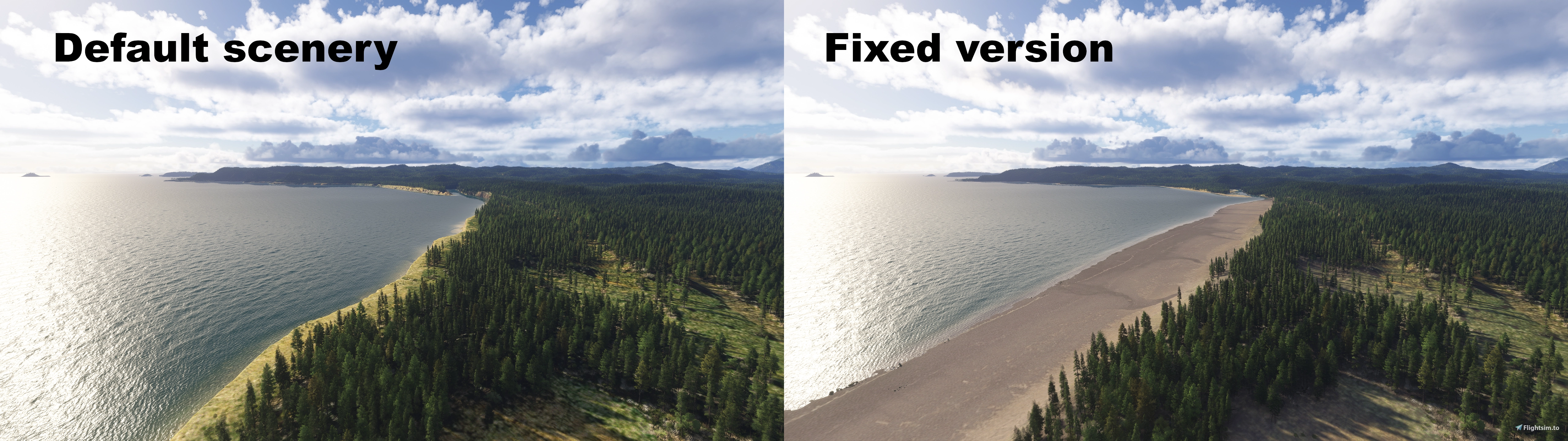
Its sole purpose is to improve the default scenery for Alaska. It looks fine in many places, and even quite good in some, but elsewhere it looks bad or downright awful. MSFS24 is a fantastic flight sim for bush flying, and Alaska feels like the ideal place to do it.
All I want is to make things better, or at least less bad, and have my fixes fit seamlessly into the default environment.
I can't realistically list every fix I've made, but here are the main areas where you'll notice changes:
- Prince William Sound (including the massive Montague Island)
- Tongass Area
- Chugach Area
- Cook Inlet
- Copper River mouth
- And more...
Overall, you'll find hundreds (thousands?) of lake and ponds and rivers fixed, thousands of kilometers of corrected coastline, color corrected satellite imagery (even some alternative imagery in one place), etc.
I’m already working on updates to expand this project. My main goal for the next update is to have a fully corrected Admiralty Island. (there are also lots of fixes for it in this release: the western and southern coastline is mostly okay now, and most lakes have been leveled and filled with water.)
How to install
Please download and extract both files to your community folder. The alternative imagery one is pretty big, and that's the reason i've put it in a different package. I don't want to reupload it everytime I make an update.
Dependencies
None. That said, I strongly recommend using these two magnificent packs of bush strips for the Alaskan landscape. Both include scenery fixes that complement my project, and I intend to keep my project compatible with their work:
- Northcoaster76's Alaska Scenery Project
- phr34k86's Alaska Bush Strips Pack
I also recommend using Bijan's Seasons Enhanced 2024.
Return to Misty Moorings?
If you want to use RTMM sceneries with this project, it will break things. I recommend not using it... for now! A new and improved version of the RTMM sceneries are coming (it will take a bit of time, though).
What's next?
I can't make a list of what I intend to work on. Alaska is a massive place, there are a lot of places that need care, and I obviously can't fix everything. For now, I intend to work on the Tongass Area, the Cook Inlet, fix things in the Merril Pass and the Rainy pass, and follow the whole Copper River. I'd love to work on Kodiak islands after that. We'll see!
Hope you'll enjoy my work!
Alaska Scenery Enhancement Project
This add-on enhances the default Alaska scenery in Microsoft Flight Simulator by correcting lakes, ponds, rivers, and coastlines, as well as color correcting satellite imagery. Major improvements include areas such as Prince William Sound, Tongass, Chugach, Cook Inlet, and Copper River mouth. The goal is to provide seamless fixes that blend into the default environment without altering airports or airstrips. No dependencies are required, and compatibility is maintained with popular Alaska scenery and bush strip packs.

Avis des utilisateurs
6 avis
Historique des versions
- Knik River cleaned and enhanced (shores, sand bars, vegetation, bridge, etc) - Compatibility with Northcoaster76's Bremner River scenery - More fixes to Inner Lake George area (elevation, vegetation, color correction, etc) - Troublesome Creek fixed - Glacier Fork Knik River fixed - Southern coast of Admiralty Island fixed - A ton of little fixes here and there. I also added a pdf file. It contains maps and information to help you understand the scope of the project, and where to find the main areas where I changed things.
Connectez-vous pour participer à la discussion
Se connecterCommentaires(24)
3 days ago
First of all: WELL DONE on your work and your determination 🙏
I’ve also wanted to try my hand at creating and optimising scenes, but I must admit it’s not easy and, above all, it’s time-consuming (I’m a graphic designer and have some background knowledge of 3D modelling, particularly with Lightwave).
I’m reaching out to you because you mentioned a PDF that I don’t think I’ve seen in the download files.
I look forward to hearing from you and wish you every success and happiness in all aspects of your future endeavours.
Warm regards from France,
Laurent
PS: I’ll soon be posting a ‘best of’ selection of shots taken in showcase mode via MSFS2024 from my flyovers in Alaska, and I’ll give you credit for your work. https://www.youtube.com/@FloatingBetweenSkyandEarth
about 8 hours ago
Merci pour le commentaire. Oui en effet, tout ça c'est beaucoup de boulot. J'espère avoir suffisament de temps pour finir la mise à jour que je prépare pour fin novembre, sinon ça sera en décembre.
Pour le PDF, il est normalement inclu dans la dernière version téléchargeable (dans l'archive "main scenery patch" et pas celle qui contient l'imagerie satellite alternative). Je viens de tester de la télécharger, et je trouve bien le fichier dedans donc normalement le PDF est bien disponible.
N'hésites pas à me dire si tu as un souci.
Merci encore !
12 days ago
10 days ago
9 days ago
https://imgur.com/a/ZQdgO81
8 days ago
8 days ago
24 days ago
24 days ago
27 days ago
25 days ago
27 days ago
25 days ago
28 days ago
25 days ago
about 1 month ago
about 1 month ago
about 1 month ago