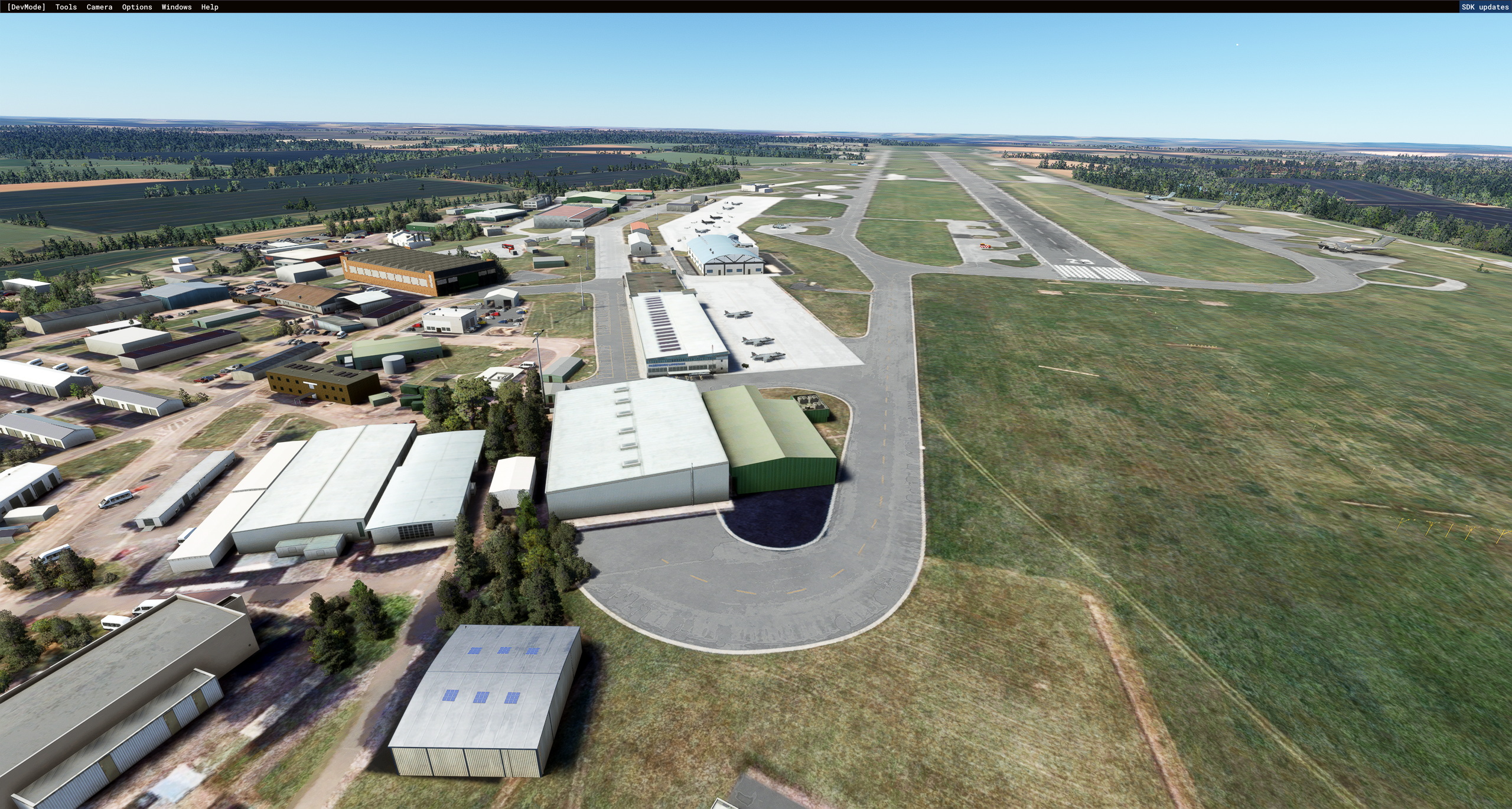
Description
Active since 1916, RAF Wittering has played a significant role in almost every major conflict for the last 100 years, including the Battle of Britain. The Harriers saw action in the Falklands, Balkans, Gulf War II and Afghanistan.
During World War One the Station served as training facility for pilots (a role to which it has now returned). During the Second World War, the station was very active during the Battle of Britain and the Blitz in 1940–41 in No. 12 Group. The airfield was bombed five times, with seventeen people being killed on 14 March 1941. Aircraft from the station downed 151 Luftwaffe aeroplanes and 89 V-1 flying bombs.
During the early 1950s the airfield at RAF Wittering was redeveloped to accommodate the arrival of the jet age. English Electric Canberras arrived in March 1954 and Valiant B1s, the first V-Bomber, arrived in July 1955.
Valiant bombers from RAF Wittering were detached to Operation GRAPPLE, a series of British nuclear weapons tests of early atomic bombs and hydrogen bombs carried out in 1957 and 1958 in the Pacific Ocean.
During the 1950s and 1960s all three V-Force bombers operated from RAF Wittering: the Valiant, Victor and the Vulcan.
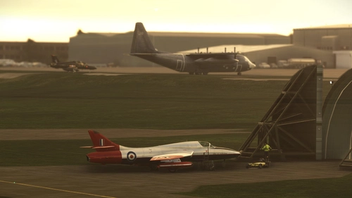
In 1969 the Harrier arrived. It was an association that lasted for over forty years. The Harriers were involved in almost every major UK conflict including the Falklands, Gulf War Two, the Balkans and Afghanistan.
In 2006 the Station became the Royal Air Force Expeditionary Logistics Hub, with the arrival of No 85 Expeditionary Logistics (EL) Wing. No 42 Expeditionary Support (ES) Wing stood up in 2007, providing a command structure for the engineering units of the A4 Force.
In 2010 the airfield fell silent with the retirement of the Harriers, but was reactivated in 2014. Wittering now provides elementary flying training to the next generation of RAF pilots.
Installation
To install the scenery, unzip the "Zip" file and place the scenery folder into your Community folder.
To see all the objects you will need all the Asobo airfields (particularly Paderborn EDLP), plus the Library files listed below.
The Harrier GR3 model can be downloaded from:-
https://militaryaiworks.com/download-hangar/file-library/download/97-aircraft-models-fsx/825-ai-bae-harrier-ii-gr3-t4-raf-gutersloh-3rd-4th-sqn-jyai
It can be converted for MSFS by using the MSFS Legacy Impoorter Tool:-
https://msfs.touching.cloud/mods/msfs-legacy-importer/
✈ Would you like to support the Tag21 Schedule Guy Channel?
Well you could buy me a coffee here :) https://www.buymeacoffee.com/TAG21
Tag21 Schedule Guy Channel Link: https://www.youtube.com/channel/UCfQdwmyBFnjjXddoyvi0Y6w
Version 1.1
Various scenery enhancements, inclusion of Vigo Wood Vertical Landing Pad, white line markers for Rolling Vertical Landings abeam the control tower and Mexe pads (100 Sq ft metal mesh pads) to simulate off base operations.
Library Links
UK2000 Common Scenery = In the Free section of the MSFS Market Place
EGOV by Skell300 = https://flightsim.to/file/9361/egov-raf-valley-custom-built
EGOW by Skell300 & Superspud = https://flightsim.to/file/4558/egow-woodvale-ab-custom-built
EGTC by JayFlySim = https://flightsim.to/file/6905/cranfield-airport-egtc
EGWU by Gobby = https://flightsim.to/file/5306/raf-northolt-egwu
EGDR by Superspud = https://flightsim.to/file/26191/egdr-rnas-culdrose-upgrade
EGYM by Nickb007 = https://flightsim.to/file/27131/raf-marham-egym
EGSU by ChicoMick = https://flightsim.to/file/28581/egsu-duxford-airfield-complete-edition
Commentaires(23)
Connectez-vous pour participer à la discussion
Se connecterabout 4 years ago
The curved-roof building between the two Harrier ramps looks out of place. Could you possibly alias another more military-looking building from a "required scenery" as you regularly do? There do seem to be better options in other RAF stations currently available. Also, not sure about that building beside the Sea Harriers. Looking on Google Earth there's no building there at all. These changes would improve the look of the scenery. Your work is MUCH appreciated!!
over 4 years ago
Great scenery, thank you. I flew from RAF Wittering with the Harrier for many years and it is great to have this scenery. Hopefully, you will add to it over the coming months. One suggestion, would you be prepared to model the Vigo Wood VL pad to the west of the airfield? It was always an interesting VL in the Harrier ;-)
over 4 years ago
Can you let me have the co-ordinates for Vigo Wood?
over 4 years ago
52°36'23.7"N 0°30'43.0"W ///depended.cassettes.dripped
As you can see it is surrounded on 3 sides by woods. The flight into the Vigo Wood was the last flight of the basic conversion section of the flying course onto the Harrier.
over 4 years ago
I have a few other ideas for small enhancements to the scenery if you are interested in the Harrier era. I was flying there on and off from 1977 to 1998.
over 4 years ago
Ok, that looks to be 1.17 Km West from the threshold of runway 07. What would be in attendance during a VL practice? - Crash Waggon - Ambulance - Land Rover?
Let me know any other ideas you have and I will see if I can build them in.
over 4 years ago
Hi. There would be a small fire truck and a landrover for the instructor pilot.
over 4 years ago
I have a couple of ideas, but they would be best shown on a bing maps photo which I cannot upload here?
over 4 years ago
You can mail me at:-
tag21@tpg.com.au
over 4 years ago
Thank you, but your email address has returned my email?
over 4 years ago
Must be Gremlins in the system. Try
thomas-grant@bigpond.com
over 4 years ago
Many thanks for the update with Vigo Wood , the mexes, and the white RVL lines. Very much appreciated.
over 4 years ago
RAF Wittering has many memories for me, so thank you for doing this one. As an Air Cadet in my teens, this was my closest RAF station. I visited Wittering quite a few times, had wing parade on the ramp with Harriers in the background, and even had a board fall on my displayed 1/72 kits, destroying years of loving work!
Ps... Looks like you have some errant buildings sitting over a roadway....
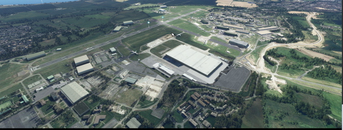
RAF Wittering - EGXT - Cambridgeshire - Tag21
Explore the rich history of RAF Wittering with this add-on, showcasing its vital role in major conflicts throughout the last century. Immerse yourself in the stations legacy, from hosting Harriers in various conflicts to its current role in training RAF pilots. Version 1.1 features enhancements such as a Vertical Landing Pad, white line markers for Rolling Vertical Landings, and metal mesh pads for off-base operations. Enhance your simulation experience with this detailed recreation of RAF Wittering and its significant contributions to military aviation.
Location
More Information
Historique des versions
Version 1.1 Various scenery enhancements, inclusion of Vigo Wood Vertical Landing Pad, white line markers for Rolling Vertical Landings abeam the control tower and Mexe pads (100 Sq ft metal mesh pads) to simulate off base operations.
Présent dans des collections(1)
Similaires
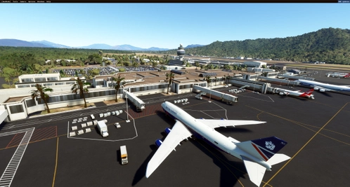
Cairns International - YBCS - Queensland - Tag21
Discover Cairns International Airport (YBCS) in Queensland, Australia. Serving as the seventh busiest airport in the country, this international airport offers direct flights to 7 international and 17 domestic destinations. Located between Mount Whitfield and Trinity Bay, it is a hub for major airlines, general aviation, and helicopter operators in the region. Explore the rich history and bustling activity of this dynamic aviation hub.
par Tag21
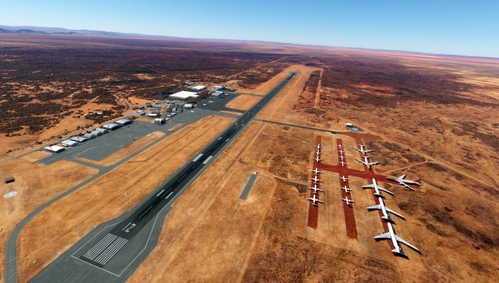
Alice Springs Airport - YBAS - Northern Territory - Tag21
Alice Springs Airport (ICAO: YBAS) is an Australian regional airport 7 nautical miles (13 km; 8.1 mi) south of Alice Springs, Northern Territory. The airport has two runways, the larger of which can accommodate the Airbus A380, Boeing 747 and 777 landing (but not a fully laden takeoff due to high temperatures and the runway length). The only scheduled flights using the airport are domestic, although international charters do use the airport on occasions.
par Tag21
RAAF Darwin Airbase - YPDN - Northern Territory - Australia - Tag21
Explore RAAF Darwin Airbase (YPDN) in the Northern Territory, Australia, recreated using the latest SDK scenery models. This forward operating base, established in 1940, played a crucial role during World War II and serves as a key transit hub in Asia. Discover this historic airfield with shared runway at Darwin International Airport.
par Tag21
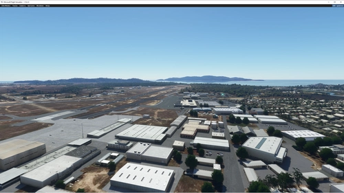
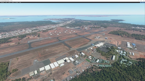
RAAF Townsville Airbase- YBTL- Queensland, Australia-Tag21
Explore RAAF Townsville Airbase in Queensland, Australia, a key defense installation hosting various deployments and support services. Version 1.1 features cosmetic improvements and removal of static airliners, while Version 1.2 corrects scenery errors post-Sim Update 7. This add-on includes a range of libraries for enhanced scenery models.
par Tag21
over 1 year ago