Description
This is a community-maintained update of the original FSPM VFR Map by Scelt, now compatible with MSFS 2020 and MSFS 2024.
To install, simply remove your existing Community\fspm-panel-vfrmap folder and unzip the downloaded file. into the Community directory.
Image tutorial: https://a5tr0.sk/this/fspm-panel-vfrmap-fix/howto2024/
Home website: https://a5tr0.sk/this/fspm-panel-vfrmap-fix/
If you enjoy the add-on, please consider supporting the author (a5tr0)!
Major New Features
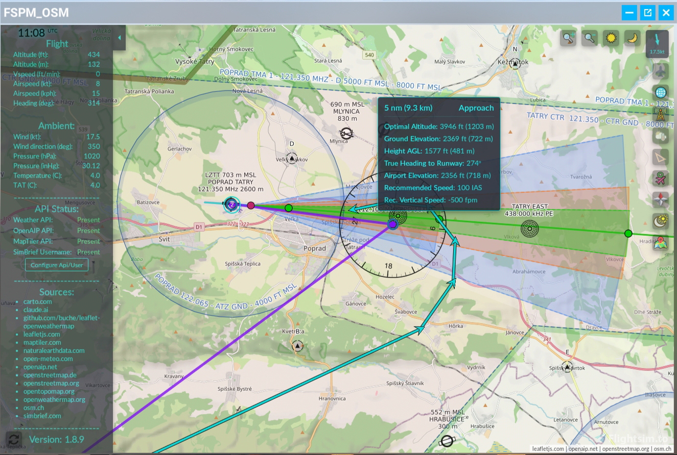
- SimBrief Integration: One-click download and display of your latest SimBrief flight plan waypoints. Requires a SimBrief (Navigraph) account and entering your username in the add-on’s API dialog.
- Runway & Approach Visualization: When a SimBrief flight plan is loaded, an approach-corridor button appears showing ILS, NPA, and visual corridors with distances, altitudes, and speeds; clicking a corridor waypoint presets teleport settings.
Enhanced Map Toggles & Tools
- Satellite, OpenAIP & Weather Layers: New buttons to toggle satellite imagery (MapTiler), airspaces/navaids (OpenAIP) and weather overlays (clouds, precipitation, wind, temperature) via free API keys.
- Trail & KML Export: Record and export your flight track to Google Earth Pro in KML format with a single click.
- Measurements & Waypoints: Improved ruler tool with multiple-point distances/headings and “For AP use” option; dedicated waypoints toggle for lines between successive navpoints.
- Teleport Enhancements: Editable coords with virtual keypad, “random lost” generator (day/land options), auto-elevation +2,500 ft, and direct heading/lat-long presets.
UI & Quality-of-Life Updates
- Adjustable map brightness and zoom (VR-friendly)
- Four-mode clock (UTC/Local/System/Off) with terminator line toggle
- Earth-curvature corrections, distortion fixes crossing the dateline
- Hide-plane icon option (state saved), blank-icon fix, status panel starts closed
- Standard VFR map key binding support (MSFS2020).
Future Plans
A5tr0 will continue maintenance and occasional fixes—enjoy!
Free Tools & Data Sources
The app uses many free tools and APIs maintained by generous community contributors. Support for these services may be discontinued at any time, but for now we can enjoy them absolutely free—please use them responsibly and contribute if you can.
Sources:
carto.com
claude.ai
github.com/buche/leaflet-openweathermap
leafletjs.com
maptiler.com
naturalearthdata.com
open-meteo.com
open-aip.net
openstreetmap.de
openstreetmap.org
opentopomap.org
openweathermap.org
osm.ch
simbrief.com
Commentaires(639)
Connectez-vous pour participer à la discussion
Se connecterabout 6 hours ago
The most important bit first: what you posted is a behavioural sandbox report (the "MITRE / Sigma / IDS / JA3 / dropped files" format), not an antivirus verdict. Those are heuristic observations of behaviour, not detections. The number that actually answers "is this malware?" is the AV detection score on VirusTotal's Detection tab - the "X / 70 engines flagged this" line. That's the one that matters, and I'd genuinely encourage you to check it; nothing in what you posted is an engine calling it malicious.
🗂️ "Dropped files: 108 + 1 PE DLL + 1 script + 1 text"
This is the scariest-looking item and it's 100% expected. The Connector is a self-contained single-file .NET app - the entire .NET runtime and its native libraries are bundled inside the one .exe so you don't have to install anything. The first time it runs, .NET unpacks those bundled libraries into a temp folder (%TEMP%\.net\…) and runs from there. That "unpack a pile of files on launch" step is exactly what the sandbox reports as 108 dropped files + a DLL. It's standard .NET single-file behaviour - nothing is written outside your own temp/install, nothing persists, nothing hides.
(Fun fact: this same self-extraction is why a handful of AV engines sometimes throw a generic false positive on single-file .NET builds - more on that below.)
🌐 Network: "18 DNS / 16 IP / 1 HTTP / 73 JA3"
It's a live VFR map + weather tool, so it contacts exactly the kinds of things a map app contacts - and nothing else:
Map tiles: OpenStreetMap, MapTiler, OpenTopoMap, Carto, tile.osm.ch, OpenAIP (aviation charts), OpenWeatherMap tiles
Weather / rain: open-meteo.com, RainViewer
Version check + anonymous usage stat: my little a5tr0.sk/…/ver2.php (ver.php in older version) (just "which version, roughly which country" - no accounts, no personal data)
Localhost: 127.0.0.1:9870 - the Connector's own local server that the in-sim panel / browser map talk to, entirely on your machine
The 16 IPs look like a lot, but map + weather tiles are served from CDNs that hand out many rotating IPs, so a handful of providers easily becomes 16 addresses. The 73 JA3 entries are just TLS fingerprints of all those HTTPS tile/weather requests - normal for anything pulling map data. No hardcoded C2, no odd ports, nothing outbound that isn't a map / weather / version endpoint.
🧩 MITRE (29 med / 26 low / 10 info), Sigma (2), IDS (2)
Generic "this program does networking, writes files, and reads some system info" heuristics. Any networked desktop app lights up dozens of them - note there's nothing High or Critical, it's all medium/low/info. The 2 Sigma / 2 IDS hits are the same flavour: "process made an outbound connection / dropped a file in temp."
On code signing: you're right that a proper signing certificate would make a lot of this look cleaner to sandboxes and AV. Honestly, this is a free hobby project and a cert just isn't something I can justify paying for right now - so I completely get it if the unsigned + self-extracting combo raises an eyebrow. It's a well-known rough edge of free .NET tools, not a sign of anything hidden.
If it helps, I'm more than happy to walk through any specific signature, hand over the complete list of endpoints it contacts, or answer anything else - I'd rather over-explain than leave anyone uneasy. Cheers, and thanks again for the diligence! ✈️
about 6 hours ago
about 1 month ago
about 1 month ago
about 1 month ago
Edit: Just did some checking. If you leave your app at it's default scale (with the no plus adjustment on the interface), the text on the map is readable at 1920p, worse at 1440, and at 4k unreadable. If you then use the interface +, there are not enough increments available to get you to a comfortable readable scale as far as map text goes. One is too big and the other too small. Hope that helps.
2 months ago
2 months ago
2 months ago
I'm sorry to hear you're experiencing this issue with the map being blocked. I tried to replicate the behavior you described, and I believe I know what's happening.
Currently, the consent/update window will keep appearing until you explicitly confirm or deny the update checks by clicking the "Continue" button. If you close the window by just clicking the "x" in the corner, your preference isn't saved. I completely understand how that can be annoying, so I will treat this as a feature request. I'll update the logic in the next version so that clicking the "x" automatically registers as a denial.
For now, please try making your selection (allow or deny) and then make sure to click the "Continue" button.
If the prompt still keeps coming back after doing that, please try using the "Factory Reset" option. Once the addon reloads, make your choice again and click "Continue" (again, please avoid just using the "x").
Important: Before doing a Factory Reset, please make sure to back up your API keys if you've entered any (under Menu > Configure API/User).
I've put together some screenshots showing exactly what to click here:
https://a5tr0.sk/fspm-osm/consent_and_reset/
Please let me know if using the "Continue" button helps resolve the issue for you! If not, please tell me exactly what steps you are taking, and I'll do my best to figure it out.
A5tr0
2 months ago
2 months ago
2 months ago
2 months ago
3 months ago
3 months ago
3 months ago
New stuff:
* The addon is more interconnected with the Connector app now, but it still works as you are used to. The addon will detect if you are running the Connector app and offer to use it as a data source - the Connector is the bridge/server between the browser/addon and MSFS, so running the Connector without using its data in-game in MSFS is wasteful and brings unnecessary CPU load. So when the addon detects the app, you will be asked if you want to use it or not - it's up to you.
* What you gain when you decide to use the Connector so far:
- Available nearby traffic from MSFS (radar button)
- Wind data from Open-Meteo visualization (may be slightly different from the MSFS wind direction data)
- Plane tracking data remembered across sessions
- Improved MSFS flight plan support
- Future plans: option to use OpenStreetMaps and OpenAIP offline (+ adding OpenFlightMaps as well). The reason is to reduce the load on the OpenStreetMaps and OpenAIP servers.
* Summary of the update:
- Traffic button (via Connector app)
- Weather menu: "Wind" visualization - open-meteo.com (via Connector app)
- Plane tracking data stored (via Connector app)
- Weather menu: "Radar" - rain and snow - rainviewer.com
- Measurement tool: "Cross-Fix Tool" for triangulation
- Measurement tool: Any point created can be moved by clicking and dragging, even when the measurement tool is closed
- Control panel: "Soft-Close/Open" keyboard shortcut: after you start the addon, you can hide/show it via a hotkey (make sure to choose a shortcut that doesn't conflict with your existing keybinds)
- Control panel: "Use connector app" - if you are running the Connector app as well, I suggest you turn this option on.
- Control panel: "Actual map view" - see the actual zoom and coordinates
- Control panel: "Show Autopilot" - still in development. Currently, when a plane has its own AP, it will turn on (HDG + ALT hold). If you draw a route via the Measurement tool and set the "AP Route" option - you can trigger the autopilot to follow that route. My aim is to make this work for planes which don't have a native AP - but right now it's still kinda too buggy to "release" :)
- Control panel: "Factory reset" - this will clear all your settings and APIs from MSFS and from the Connector app if it is connected.
- Tiny optimizations for mobile displays, but I would use those only for viewing, not direct interaction (tablets should be ok).
- Addon update notification
- A couple of bugs fixed, but with this amount of changes, you might find some new ones - just report them here or send me a private message.
* Thank you kindly for supporting the development and future updates of this addon 💜☕ :
- https://buymeacoffee.com/a5tr0.sk
* Download: https://a5tr0.sk/fspm-osm/
- It will also be available for download on Flightsim.to soon
3 months ago
Before the update, I had a button assigned to open the 'Display map'. Back then, both the original VFR map and this tool opened simultaneously. Now, only the original map opens.
Is there a way to reassign this or fix the shortcut?
Thanks!"
3 months ago
I removed this default behavior based on users feedback, and because using this shared key binding trick actually causes the entire addon to fail in MSFS 2024 — this will work only in MSFS2020 version.
However, if you download the latest version of the addon (1.10.0), which I will be posting shortly as separate post, you can easily restore the behavior you are used to!
Here is how to do it:
Download and install version 1.10.0 in your Community folder as usual.
Navigate to Community\fspm-panel-vfrmap\InGamePanels\.
Double-click and run the KEY_SHOW_VFRMAP-activate.bat file.
This script will automatically back up the standard file and apply the alternate configuration. After running it, pressing your map key will open the addon map alongside the default one again.
If you ever want to revert these changes in the future (for example, when transitioning to MSFS 2024), simply run the KEY_SHOW_VFRMAP-deactivate.bat file located in that same folder to restore the default settings.
Let me know if you run into any issues!
Updated version of addon is available now on my site, soon will emerge also on flightsim.to:
https://a5tr0.sk/fspm-osm/
3 months ago
Thank you very very much to make this feature possible those who stuck with 2020 version :D Many thanks!!
FSPM/OSM VFR Map
The FSPM/OSM VFR Map is a community-maintained modification of the original FSPM VFR Map, designed for compatibility with MSFS 2020 and MSFS 2024. It offers features such as SimBrief integration for flight plan management, runway and approach visualization, and various map overlays including satellite imagery, airspaces, and weather. The tool also includes enhancements for teleportation, measuring distances, and exporting flight tracks, while providing user-friendly interface updates and quality-of-life improvements.

Avis des utilisateurs
142 avis
More Information
Historique des versions
- Traffic button (via Connector app) - Weather menu: "Wind" visualization - open-meteo.com (via Connector app) - Plane tracking data stored (via Connector app) - Weather menu: "Radar" - rain and snow - rainviewer.com - Measurement tool: "Cross-Fix Tool" for triangulation - Measurement tool: Any point created can be moved by clicking and dragging, even when the measurement tool is closed - Control panel: "Soft-Close/Open" keyboard shortcut: after you start the addon, you can hide/show it via a hotkey (make sure to choose a shortcut that doesn't conflict with your existing keybinds) - Control panel: "Use connector app" - if you are running the Connector app as well, I suggest you turn this option on. - Control panel: "Actual map view" - see the actual zoom and coordinates - Control panel: "Show Autopilot" - still in development. Currently, when a plane has its own AP, it will turn on (HDG + ALT hold). If you draw a route via the Measurement tool and set the "AP Route" option - you can trigger the autopilot to follow that route. My aim is to make this work for planes which don't have a native AP - but right now it's still kinda too buggy to "release" :) - Control panel: "Factory reset" - this will clear all your settings and APIs from MSFS and from the Connector app if it is connected. - Tiny optimizations for mobile displays, but I would use those only for viewing, not direct interaction (tablets should be ok). - Addon update notification - A couple of bugs fixed, but with this amount of changes, you might find some new ones - just report them here or send me a private message. * Thank you kindly for supporting the development and future updates of this addon 💜☕ : - https://buymeacoffee.com/a5tr0.sk
Similaires

Gees - In game landing analysis (standalone App)
Enhance your landing skills with Gees, a standalone app designed for landing analysis in Microsoft Flight Simulator 2020. This tool provides insights into key metrics such as descent rate, G force at touchdown, airspeed, ground speed, wind speed and direction, and sideslip angle. Improve your performance and receive real-time feedback on your landings.
par scelt

GEES 2.0 Landing Analysis for MSFS
Enhance your landing skills with GEES 2.0 Landing Analysis for MSFS. This in-game add-on provides detailed feedback on your landing rate, G-force, speed, wind conditions, sideslip, bounces, and landing location. It also offers instant replay recording to review your landings and can be easily installed by copying files into the Community folder. Improve your piloting abilities and track your progress with GEES 2.0.
par scelt
1 day ago
Mitre signatures
29 medium
26 low
10 info
IDS rules
2
Sigma Rules
2 Medium
Dropped files
108 others
1 script
1 Pe Dll
1 text
Network Comms
18 Dns
16 IP !!!
1 HTTP
73 JA3