Description
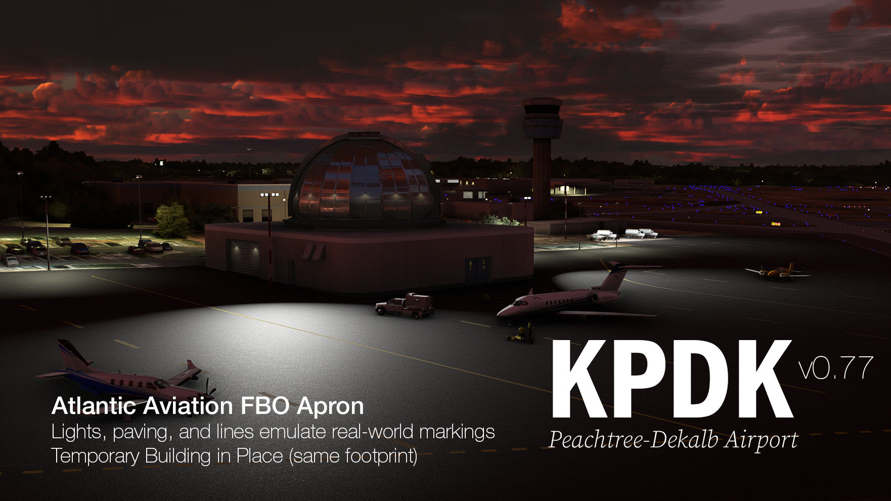
The Busiest Little Airport: Peachtree-Dekalb
I'm making this scenery enhancement because I live near KPDK, am a vZTL controller, and drive by it often. The stock AI generate scenery pains me to use. Especially the runways that with bumps that will launch you. This is not the Ground Effect we wanted, ASOBO. And these taxiways. The AI taxiway markings make this place impossible to navigate.
Furthermore, the AI generated buildings were based on 2013 aerial imagery, so (1) the entire Atlantic Aviation (NetJets) ramp is outdated; (2) Signature FBO building looks more like a Lego than the protective overhang in the real world.
These fixes and more are in this for Peachtree-Dekalb Airport. Come do some pattern work, visit downtown Atlanta, or fly IFR in and out of the Atlanta A80 Tracon without having to dodge the Big Bois flying into Hartsfield-Jackson. We'd love to see y'all in our satellite airspace!
The differences in taxiway colors and apron colors is part of KPDK's charmPeachtree-Dekalb was once Camp Gordon, an WW2 training airfield. There's some really old pavement here mixed in with the newer concrete to service the private jets.
WAY better than default, but terrain is stock.The Atlanta regions is pretty hilly, so KPDK has lots of different gradients and elevations at work. RWY21L and 21R takes off slightly uphill. West Ramp and Clairmont Ramps are about 25 feet above the Northwest Ramps. Only RWY21L has accurate gradients and elevations. I can't do the rest until Asobo somes serious adjustments to the terrain stitching engine. It creates some very clear terrain curbs that I can't smooth out despite having thrown 20 hours at it, trying out rectangles, polygons at varying elevations and drop-off distances.
If you'd like to help out with the terrain, let me know!
Assistance Requested
- If you know how to use Blender, I would love to get some help modeling the Atlantic Avaiation building, and the Epps hangar.
In the current version
RWY 21L/3R
- ILS Frequencies, Glideslope, DME
- Real-World Approach Lighting and Edge Lighting
- Real-World Glide Slope Indicator
- Accurate Elevations and Gradients
- AI usable
RWY 21R/3L
- No Approach Lighting in Real-Life, but Edge Lighting exists
- Real-World Glide Slope Indicator
- PLANNED: Accurate Elevations and Gradients
- AI usable
RWY 16/34
- No Approach Lighting in Real-Life, but Edge Lighting exists
- Real-World Glide Slope Indicator
- Accurate Elevations and Gradients
- AI doesn't use this because it's only used for taxiing and airshows
Helicopter Express Helipads, Aprons, and Hangars
- 4 Helipads placed, works with AI traffic. Unfortunately you spawn with systems on. WHY ASOBO?
- Stock Hangars handplaced to replace AI gen buildings
- static ground vehicles placed because apparently they park lots of vehilces on the old helipads
Taxiways
- UPDATED to match real-world taxiway C, F, and N.
- All taxiway signs placed
- All taxiway Edge Lights placed
- Taxiway intersection pavements placed (B, C, E, F, G, H, J, paving material colors emulated)
Aprons
- Handplaced Apron Lighting
- Just a few parking spots for now with accurate ramp naming (planning >100 handplaced parking spots)
Scenery Additions
- Signature FBO that you can park under. enjoy!
- Handplaced Streetlamps. YES. Streetlamps. There're exactly where they should be on Airport Rd and Corsair Rd
- Handplaced VOR, Beacon
- Handplaced Hangar and Lights, more to come
Quality Assurance
- Drove every taxiway and runway to ensure there are no bumps
- Flew the ILS
- Did some pattern work
Minor Dependencies:
- KATL VOR (MSFS US Scenery)
- EGGP Tower (MSFS European Scenery)
- EDHK Lights & Objects (https://flightsim.to/file/2549/edhk-lights-pack)
In the future
- Basic shell of Atlantic Aviation building, Atlantic Aviation new hangars
- Replacing AI generated buildings with stock buildings
- Placing Aprons on most ramps
- Elevation of Clairmont Ramp
- East Ops area
- AI and nav help usable Taxiways D, J, C, N
- More parking
- More apron lights
Commentaires(36)
Connectez-vous pour participer à la discussion
Se connecterabout 1 year ago
about 2 years ago
over 2 years ago
over 2 years ago
over 2 years ago
almost 3 years ago
almost 3 years ago
Why onl one daylight image?
almost 3 years ago
Because I wanted to show off the lighting work :)
almost 3 years ago
about 3 years ago
As with your KLZU airport, thanks! I used to take my daughter there in the evenings to watch the planes take-off/land. They used to have a nice little 'park area' where people could sit and watch...been many years, so I do not know if it still exist.
Thanks for this airport and your KLZU (Lawrenceville) one too!
:)
about 3 years ago
Yes that playground area is still there, and well maintained. Any given weekend you can see a dozen kids climbing around :)
about 3 years ago
That's nice. It was a nice thing they did too by even making such a place. As far a 'small airports', I think this is the only one to have such things for people in Atlanta. It is a nice touch and I glad that they have kept it up. I live about 60 miles away now (Canton), so I have not seen that airport in 30+ years.
Thanks again!
:)
PS - I thought I would ask ya...do you have a copy of the airport here in Canton? KCNI? There is one on here, but the guy has disappeared and the file now is just a JPG pic. Others had the same 'result' as me too. :(
If so, could I get a copy from ya? Thanks! :)
about 3 years ago
The metro Atlanta airports are all very significant and historical. KPDK began as a Naval Training station and was used up into the 1960s until Dobbins KMGE was built (birthplace of the C130, C141, C5A, and F22).
KFCC is now the location for the Commemorative Air Force. north on Bravo past Alpha and turn right... you can get rides on the P51 Mustang, Navy TBM, T6, PT-19, or Bird Dog. Or just watch the FG-1D Corsair take off if you are lucky.
This airport is home to numerous Vans RV aircraft owned by pilots from various airlines. Some weekends it looks like a MSFS group flight with a dozen or more RVs taking off information.
ATP flight school has an operation north of Alpha as well as other flight schools with Cessnas and Dimond aircraft.
For Gliders, 5A9 Roosevelt Memeorial is the place for glider training and flights.
If you are into sky diving or Gyro aircraft, 4A4 Polk County.
Want to know about Georgia airports, flight training, or air ops, let me know.
about 3 years ago
Very nice work. 100 times better than stock. The east ops area is used for helicopter training with circuits to the east landing in the east ops aera. the northern helicopter ops area is very active with PHI, and news helicopters. Childrens Hospital uses the new Atlantic ramp. Helicopter flight School with R22, R44, and R66 helicopters is run off the Signature ramp. This is also where V22s and S76 helicopters come to refuel. There is no "H" painted on the ramp. Tours flights also ran off that ramp.
In front of the new tower there is a miniature airport playground with seating area to watch the planes take off and land... this is a very busy airport with constant corporate and private aircraft all day. Very challenging for new controllers because of the vary diverse aircraft and is used for training.
There is commercial scheduled flights out of Signature to Ohio using the four engine 146 commuter addon.
For static aircraft, Cirrus and Cessna are used for training on the Clarmont ramp along with PC6 aircraft, with EPPS as a distributor. Most of the corporate jets are at Atlantic and Signature.
Great job.
about 3 years ago
Sorry... PC12s are sold at EPPS... always a few on the ramp. The EPPS hanger has a very popular elevated restaurant for viewing aircraft ops. to the south of the new large Atlantic Hangar is the 57th Fighter WWII themed restaurant. Frequent war bird rides occur here. Waco, T6, Bird Dog, etc... there is pads for parking and loading just off taxiway Alpha.
KPDK Peachtree-Dekalb County (Georgia, USA) Taxiway & Apron Updates & Realism Enhancements (SU12)
Don't you hate it when the AI stock scenery makes bumpy terrain and doesn't generate the right taxiway signs? These fixes and more in this mod to enhance your flights through KPDK Peachtree-Dekalb Airport. Come do some pattern work, visit downtown Atlanta, or fly IFR in and out of the Atlanta A80 Tracon under the big bois.

Avis des utilisateurs
4 avis
Location
More Information
Historique des versions
Not much exciting cosmetics except for the taxiway detailing, but all taxiways now connected and usable by AI pilots and MSFS ATC. Newly paved and painted taxiway intersections this update: Taxiway H between B and D Taxiway E between B and D Taxiway D between H and RWY 21R RWY 3L exits to B, D, RWY 3R exits to D Newly paved areas this update: Northwest Ramp (partial) Epps Aviation ramp Taxiway B lines, textures, and detailing Taxiway K lines, textures, and detailing up to just before Clairmont Ramp
Similaires
![KAVL RWY+TXWY Fixes, Apron Enhancements, Night Lighting (Asheville, NC, USA) [SU11]](https://cdn.flightsim.to/images/22/kavl-runway-taxiway-apron-fix-RuXah.jpg?width=500)
KAVL RWY+TXWY Fixes, Apron Enhancements, Night Lighting (Asheville, NC, USA) [SU11]
Did you follow the ILS to land on a closed runway? Maybe you sidestepped to the scenery runway because it just felt wrong?? MSFS 2020 scenery and FSXenery payware is still living in the past, using a runway that is now Taxiway B. Be in the present, true to charts, with this mod.
par mangosprout
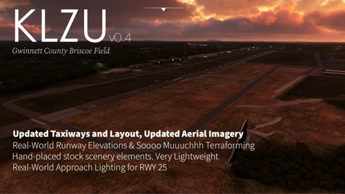
KLZU Gwinnett County Briscoe Taxiway Updates & Field Enhancement (Georgia, USA)
Gwinnett County Briscoe field has a newly reworked taxiway as of Spring 2021 and gosh darn what a surprise, old Bing scenery doesn't have it it. With this scenery, you can now taxi to RWY 25 via T D Y just like in real life. By the way, did the stock malformed runways and taxiway make you wince for your landing gears or turn your plane in a low-rider? Me too. It was a labor of Love to Terraform this place using the built-in tools (polygons and rectangles), but after throwing myself at this one 6 hours, I finally was able to make accurate elevation and gradients for the runway, taxiways, the aprons, and even the creek bed!
par mangosprout
9 months ago