Description
Pic du Midi de Bigorre Observatory (France) Version 2
This update concerns the repositioning of the Observatory on the Bing photogrammetric data, the rectification of the top of the mountain (terraforming) without adding photographic or other data.
The following have been added to this scene
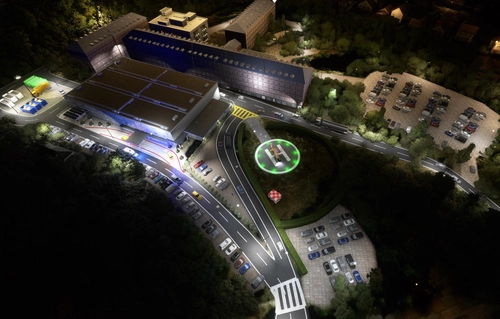
- La Mongie helipad - the departure base for medical evacuations. Note that it is possible to take off from this location with the engine stopped.
ICAO = HMON ----> Parking 0
- the complete Col du Tourmalet scene with night textures
INSTALLATION :
Delete the previous version from your Community directory and unzip the archive into it.
IMPORTANT: delete the directory containing the Pic du Midi observatory in the lighthouse pack v 2.3 dated 24 October 2023
Requires: https://flightsim.to/file/55180/airport-lights-replacement and https://flightsim.to/discover/tsr-windy-things
Enjoy your discovery and good flights
Many thanks to Michel78320 and mamu82 for their help and valuable advice.
Observatoire du Pic du Midi de Bigorre (France) Version 2
Cette mise à jour concerne le repositionnement de l'Observatoire sur les données photogramétriques Bing, la rectification du sommet de la montagne (terraforming) sans ajout de données photographiques ou autres.
Sont ajoutés à cette scène :
- l'héliport de la Mongie - base de départ pour les évacuations médicales. A noter qu'il est possible de décoller de ce lieu moteur arrêté.
ICAO = HMON ----> Parking 0
- la scène complète du Col du Tourmalet avec textures nuit
INSTALLATION :
Supprimer la précédente version de votre répertoire Community et décompresser l'archive dans celui-ci.
Nécessite : https://flightsim.to/file/55180/airport-lights-replacement et https://flightsim.to/discover/tsr-windy-things
IMPORTANT : supprimer le répertoire contenant l'observatoire du Pic du Midi dans le pack des phares v 2.3 du 24 octobre 2023
Bonne découverte et bons vols
De chaleureux Merci à Michel78320 et mamu82 pour leurs aides et précieux conseils.
The scene works perfectly with the update V. There are no duplicates.
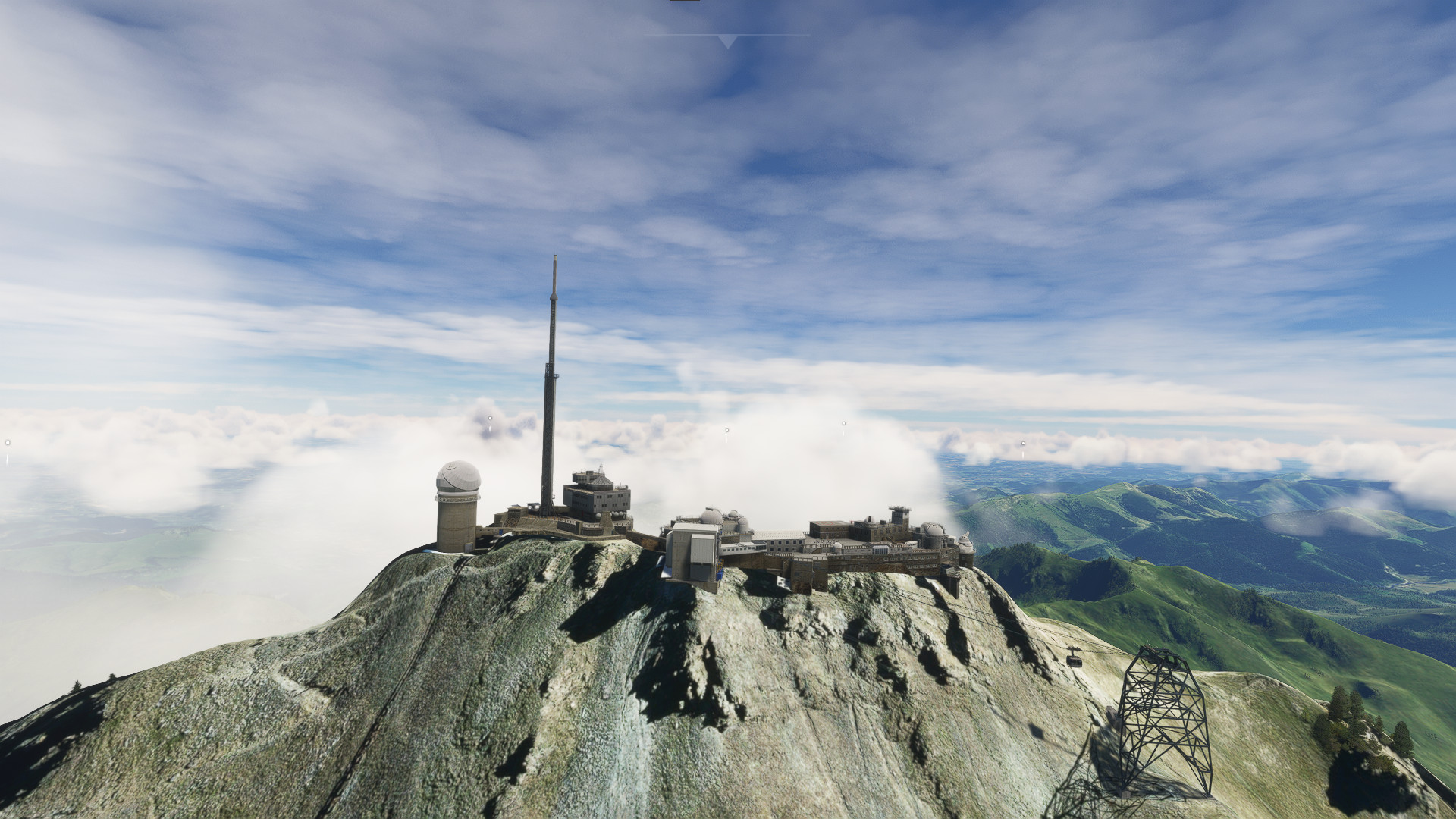
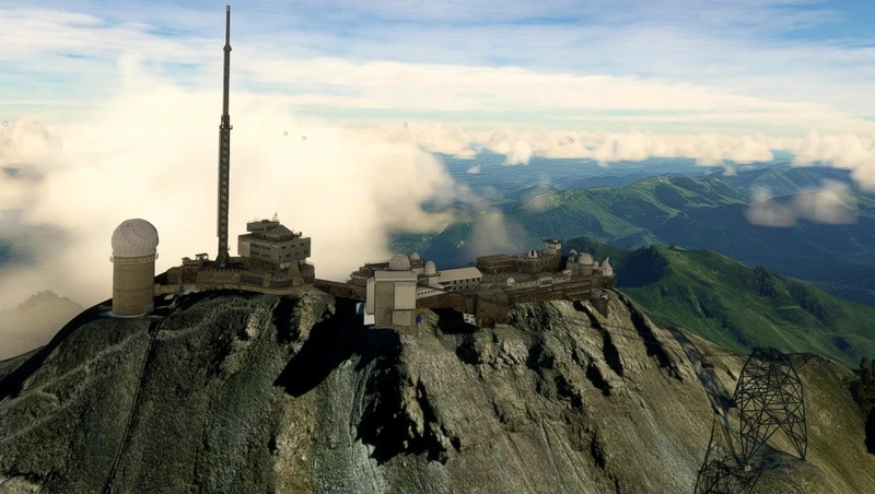
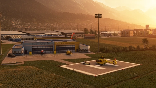
Welcome to the Pic du Midi de Bigorre Astronomical Observatory.
It is located in France in the Pyrenees at the summit of the Pic du Midi de Bigorrean altitude of 2877 m/9940 ft. It is an important place for observation and research. Meteorology and then astronomy were the
meteorology and astronomy were the main motivations for the creation of this observatory. This scene has been entirely model 3d model for FS9 in 2008, taken up in 2013 for FSX and adapted to MSFS 2020 in 2021 (44217 polygons). It conforms to the reality.
It features a hard helicopter surface for landing. Four animated domes, pylon, cables and cable cars, intermediate stationand the site of the Col du Tourmalet (2115 m/9438 ft) are represented in the scene. The ground around the Pic has been remodelled by patient terraforming.
The so-called Asobo scene included in the France/Benelux update is removed by an exclude.
Pic du Midi de Bigorre: latitude 42.9368 - long 0.141434
Col du Tourmalet: latitude 42.9084 - longitude 0.145323
More information, aircraft flight plan and helicopter approach in the subdirectory X:\-----\Community\Observatoire_PDM_v2\Instructions_Flight_Plan
Have a good discovery and a good flight.
Alro
Another helicopter challenge? : https://fr.flightsim.to/file/13133/animated-light-vessel-east-goodwin
--------------------------------------------------------------------------------------------
Bienvenue à l'Observatoire Astronomique du Pic du Midi de Bigorre.
Il se situe en France métropolitaine dans les Pyrénées au sommet du Pic du Midi de Bigorre à une altitude de 2877 m/9940 ft. C'est un haut lieu d'observation et de recherche. La météorologie puis l'astronomie ont été les principales motivations de la création de cet observatoire.
Cette scène a été entièrement modélisée en 3d pour FS9 en 2008, reprise en 2013 pour FSX et adaptée à MSFS 2020 en 2021 (44217 polygones). Elle conforme à la réalité.
Elle comporte une surface hélicoptère dure permettant un posé. Quatre coupoles animées, pylone, câbles et cabines téléphériques, la gare intermédiaire du Taoulet ainsi que le site légendaire du col du Tourmalet (2115 m/9438 ft) sont représentés dans la scène.
Le sol autour du Pic a été remodélisé par un patient terraforming.
La scène dite Asobo incluse dans la mise à jour France/Bénélux est supprimée par un exclude.
Pic du Midi de Bigorre : latitude 42.9368 - longitude 0.141434
Col du Tourmalet : latitude 42.9084 - longitude 0.145323
Plus d'informations, plan de vol avion et approche en hélicoptère dans le sous-répertoire
X:\-----\Community\Observatoire_PDM_v2\Instructions_Flight_Plan
Bonne découverte et bon vol à tous.
Alro
Un autre défi hélico ? : https://fr.flightsim.to/file/13133/animated-light-vessel-east-goodwin
Commentaires(60)
Connectez-vous pour participer à la discussion
Se connecter5 months ago
Tout d'abord permettez moi de vous souhaiter une très bonne année 2026 bien évidemment avec d'excellents vols découverte dans le monde de Flight Simulator.
Pour vous répondre, mis à part votre message, je n'ai pas eu ce genre d'information.
Question : dans quel répertoire avez placé la scène Observatoire_PDM_v2 ?, il faut quelle soit dans le Community et non pas dans le Community 2024.
Si tel est le cas, vérifier que vous avez bien le fichier PDM_v2.bgl dans le sous répertoire :
X:\MSFS2024\Community\Observatoire_PDM_v2\scenery\PDM_v2.bgl
Si le problème persiste, supprimer le répertoire Observatoire_PDM_v2 et refaite une installation. Normalement tout devrait renter dans l'ordre.
Bonne journée et bons vols
CDT,
Alain
5 months ago
Je vais contacter des experts pour les informer de ce problème et la solution qu'ils me proposent.
Je vous tiens au courant
CDT
5 months ago
Pas de soucis, je suis moi même développeur amateur sur FS2024 et ce n'est pas simple.
9 months ago
A few notes:
1. The scenery either loads super slowly or is somehow bugged (link above, scenery appears @ 1:04:47
2. clipping on triangular sections of the condola tower 1:13:56
3. collision surfaces missing from the Sky pontoon (circular part & guard rails) 1:15:20 →
4. Point-type light 1:22:24. I didn't install the light library as it isn't marked as FS24 compatible.
5. Can you add white&red anti-collision lights, if this place has any?
6. I'm unable to see any Windy Things' objects. I don't see the same barrels on the helipad as in the screenshots, perhaps something else is missing.
7. Collision mesh to the condola wires? I crash though them soon after the scenery appears. This is a design choice obviously and just a note.
8. It seems impossible to move in&out from the helipad without supernatural powers. Can you add an invisible ramp or something?
9 months ago
After checking, I did not notice the visibility issue you mentioned. The Observatory scene displays correctly at long distances (La Mongie helipad). I asked a friend to check, and he did not notice this issue either.
I think there must be, without being able to say for sure, a misconfigured value in your settings. If this is not the case, move the scene to the Community folder in FS2024, which is what I do for all my creations.
As for the other issues, I'll be revisiting it in a few days to make it 100% compatible with FS24. It'll take me a bit of work ;-)
As for night lighting, there isn't any except for a few windows lit up in red or green, just like in real life. There should be no light pollution because the observation of “objects” in the solar system is carried out at night :-)).
I would add that in reality, there is no windsock, but I have placed one to make landings easier, as it is more “convenient” when facing the wind.
Finally, all my 3D models are 75% compatible with FS24, except for the animations, and if you want to have a little more fun:
https://flightsim.to/file/13133/animated-light-vessel-east-goodwin
Amicalemnt,
Alain
9 months ago
A test flight from La Mongie worked better yesterday on same settings. It could be a general package loading issue. FS24 has a stricter LOD system, which I recommend to test as well.
I'll test the ship package, thanks.
9 months ago
Are you still having the same problems displaying the Pic scene?
Where did you find the character walking around the observatory? Excellent find, I'd love to take advantage of it because it allows us to visualize any errors.
Thank you,
Have a nice day
Amicalement,
Alain
9 months ago
The Avatar-mode is default in FS24, default keybinding is SHIFT+C.
9 months ago
By the way, I live in France, how about you?
9 months ago
over 2 years ago
These are the coordinates according to Google Maps
Leave out the altitude part perhaps?
over 2 years ago
over 2 years ago
over 2 years ago
over 2 years ago
over 2 years ago
After checking, it is quite possible to land at the Pic du Midi Observatory.
I think you're confusing it with the Asobo Observatory, which doesn't have a hard surface to land on.
Have you downloaded and installed this file? Observatoire_PDM_2020_ceklP.rar
over 3 years ago
Works perfectly, looks great
and is a great upgrade for the MSFS.
It is compatible with SU11,
thanks for that
over 3 years ago
Thank You!
Astronomical observatory of the Pic du Midi (Helipad)
Discover the revamped Pic du Midi Observatory in France with added features such as the La Mongie helipad and complete Col du Tourmalet scene. This scenery, meticulously recreated for Microsoft Flight Simulator, includes a detailed 3D model and a helipad for challenging landings. Immerse yourself in this high-altitude observation and research hub with accurate representations and detailed terraforming.
Avis des utilisateurs
20 avis
Historique des versions
Similaires
Helipads in Northern Bavaria + Emergency scenarios 2.3
Add-on featuring helipads around hospitals in Northern Bavaria, allowing for immersive emergency scenarios and HEMS pilot roleplay. Recent updates include realistic hospital remodels and helipad additions. Night lighting and proper wind socks enhance the experience.
par ChrisPiAviation
Christoph 31
Experience lifelike rescue missions in Berlin with the Christoph 31/Berlin add-on. This scenery package features custom-made helipads, hospitals, and mission locations across the city. Embark on primary rescue missions with Christoph 31 or perform intensive care patient transfers with Christoph Berlin. Explore various hospitals and landmarks while navigating through realistic scenarios.
par 30West
Krankenhaus- & Einsatzpaket NDS
An extensive add-on package featuring 67 missions and 34 hospitals in Niedersachsen and surroundings, all navigable via ICAO codes. Regular updates with improvements and new content are provided. External dependencies are required for full functionality. Experience diverse rescue scenarios in Microsoft Flight Simulator.
par Airforce81 // AcMcFat
Innsbruck Region Helipads + Emergency Scenery
Explore a collection of new helipads in the Innsbruck region, including Christophorus 1 base station and various hospitals. Additionally, discover emergency scenery for a more immersive flight experience. Simply install the desired packages in your community folder and restart the sim to begin your helicopter adventures in this picturesque area.
par Lukeeep
5 months ago
Très belle scène!
J'ai une superposition de scène entre celle d'Asobo et la votre je pense. J'ai l'antenne en double ainsi que le télescope de 2m. Auriez vous une idée pour ne pas afficher celle d'Asobo?
Je suis sur Fs2024